Al Wafrah night lights from space
Night Light of Al Wafrah (Al Aḩmadī) from space (Kuwait) Src. Average luminocity for 10x10km area is 33.5947% and for 50x50km: 16.8356%.
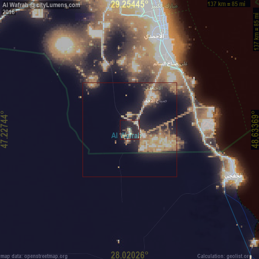
Analysis of Al Wafrah night lights 2016
Square area 10x10 km:
 1.89%
1.89%90-99
5.49%80-89
2.27%70-79
2.27%60-69
6.25%50-59
1.33%40-49
7.39%30-39
10.61%20-29
30.68%10-19
24.24%0-9
7.58%Square area 50x50 km:
1.35%90-99
2.17%80-89
1.83%70-79
2.93%60-69
4.55%50-59
2.14%40-49
2.28%30-39
2.61%20-29
5.85%10-19
10.84%0-9
63.44%Clear (daylight) street map image can be seen on geolist.org.
Map coordinates:
29° 15' 16" North, 47° 13' 38.8" East
28° 38' 21" North, 47° 55' 50" East
28° 1' 12.9" North, 48° 38' 1.3" East
Some cities around Al Wafrah sort by population:
• Al Aḩmadī
50.9 km =31.6 mi,  17°
17°
• Al Faḩāḩīl
53 km =32.9 mi, 21°
• Al Khafjī, SA
59.1 km =36.7 mi,  112°
112°
• Ar Riqqah
58.6 km =36.4 mi, 15°
• Al Manqaf
54.5 km =33.9 mi, 21°
• Al Finţās
62.3 km =38.7 mi, 17°
• Al Mahbūlah
59.5 km =37 mi, 19°
• Mubārak al Kabīr
63.1 km =39.2 mi,  13°
13°
285760 (p: 10,017)
Sources (retrieved 2019-11-25):
» Earth at Night: Flat Maps 2012, 2016