Al Mahbūlah night lights from space
Night Light of Al Mahbūlah (Al Aḩmadī) from space (Kuwait) Src. Average luminocity for 10x10km area is 82.8135% and for 50x50km: 49.0764%.
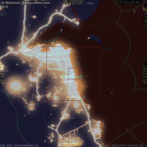
Analysis of Al Mahbūlah night lights 2016
Square area 10x10 km:
 47.62%
90-99
9.72%80-89
0.4%70-79
6.35%60-69
19.25%50-59
8.53%40-49
6.15%30-39
1.98%20-29
0%10-19
0%0-9
0%Square area 50x50 km:
20.23%90-99
7.73%80-89
2.84%70-79
6.41%60-69
10.03%50-59
5.25%40-49
3.86%30-39
4.27%20-29
3.74%10-19
3.18%0-9
32.47%Clear (daylight) street map image can be seen on geolist.org.
Map coordinates:
29° 45' 26.1" North, 47° 25' 37.8" East
29° 8' 42" North, 48° 7' 49" East
28° 31' 44.7" North, 48° 50' 0.3" East
Some cities around Al Mahbūlah sort by population:
• Al Aḩmadī
8.8 km =5.5 mi,  210°
210°
• Şabāḩ as Sālim
14.4 km =8.9 mi,  330°
330°
• Al Faḩāḩīl
6.9 km =4.3 mi,  180°
180°
• Ar Riqqah
3.5 km =2.2 mi,  271°
271°
• Salwá
17.5 km =10.9 mi,  343°
343°
• Bayān
19.3 km =12 mi, 335°
• Al Finţās
3.3 km =2.1 mi, 344°
• Mubārak al Kabīr
6.5 km =4 mi,  319°
319°
285782 (p: 18,178)
Sources (retrieved 2019-11-25):
» Earth at Night: Flat Maps 2012, 2016