Vetluzhskiy night lights from space
Night Light of Vetluzhskiy (Kostroma Oblast) from space (Russia) Src. Average luminocity for 10x10km area is 22.7823% and for 50x50km: 1.0298%.
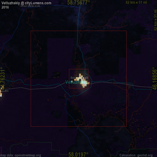
Analysis of Vetluzhskiy night lights 2016
Square area 10x10 km:
 1.02%
1.02%90-99
5.78%80-89
7.03%70-79
3.51%60-69
2.95%50-59
0.57%40-49
0.45%30-39
0%20-29
0.57%10-19
25.96%0-9
52.15%Square area 50x50 km:
0.04%90-99
0.23%80-89
0.28%70-79
0.14%60-69
0.14%50-59
0.02%40-49
0.02%30-39
0%20-29
0.02%10-19
1.24%0-9
97.86%Clear (daylight) street map image can be seen on geolist.org.
Map coordinates:
58° 45' 24.4" North, 44° 45' 44.3" East
58° 23' 24.6" North, 45° 27' 55.5" East
58° 1' 10.9" North, 46° 10' 6.8" East
Some cities around Vetluzhskiy sort by population:
• Shar’ya
3.7 km =2.3 mi,  128°
128°
• Shakhun’ya
104.2 km =64.7 mi,  139°
139°
• Manturovo
41.5 km =25.8 mi,  260°
260°
• Uren’
105.7 km =65.7 mi,  169°
169°
• Neya
93.8 km =58.3 mi, 263°
• Nikol’sk
127.3 km =79.1 mi,  359°
359°
• Makar’yev
112.5 km =69.9 mi,  240°
240°
• Leninskoye
95 km =59 mi,  94°
94°
473903 (p: 13,229)
Sources (retrieved 2019-11-25):
» Earth at Night: Flat Maps 2012, 2016