Verkhneyarkeyevo night lights from space
Night Light of Verkhneyarkeyevo (Bashkortostan Republic) from space (Russia) Src. Average luminocity for 10x10km area is 0.2055% and for 50x50km: 0.0734%.
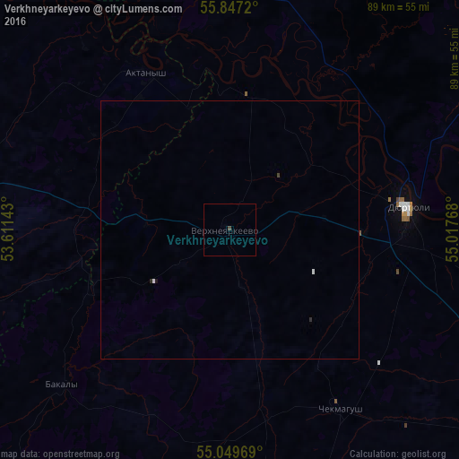
Analysis of Verkhneyarkeyevo night lights 2016
Square area 10x10 km:
 0%
0%90-99
0%80-89
0%70-79
0%60-69
0%50-59
0%40-49
0.5%30-39
0%20-29
0%10-19
0%0-9
99.5%Square area 50x50 km:
0.02%90-99
0.01%80-89
0%70-79
0%60-69
0%50-59
0%40-49
0.03%30-39
0.01%20-29
0.04%10-19
0.02%0-9
99.86%Clear (daylight) street map image can be seen on geolist.org.
Map coordinates:
55° 50' 49.9" North, 53° 36' 41.1" East
55° 27' 1.7" North, 54° 18' 52.4" East
55° 2' 58.9" North, 55° 1' 3.6" East
Some cities around Verkhneyarkeyevo sort by population:
• Neftekamsk
71.4 km =44.4 mi,  357°
357°
• Dyurtyuli
35.2 km =21.9 mi,  82°
82°
• Agidel’
56.1 km =34.9 mi,  334°
334°
• Chekmagush
41.5 km =25.8 mi,  148°
148°
• Bakaly
44.3 km =27.5 mi,  227°
227°
• Aktanysh
33.5 km =20.8 mi, 334°
• Muslyumovo
72.6 km =45.1 mi,  256°
256°
• Karakulino
73.1 km =45.4 mi, 328°
475438 (p: 9,357)
Sources (retrieved 2019-11-25):
» Earth at Night: Flat Maps 2012, 2016