Sharypovo night lights from space
Night Light of Sharypovo (Krasnoyarskiy) from space (Russia) Src. Average luminocity for 10x10km area is 15.9549% and for 50x50km: 1.2532%.
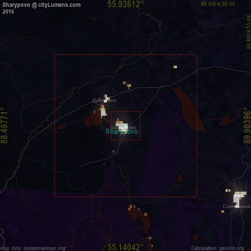

Analysis of Sharypovo night lights 2016
Square area 10x10 km:
 4.01%
4.01%90-99
3.51%80-89
0.5%70-79
1.25%60-69
0.75%50-59
3.26%40-49
0.75%30-39
0%20-29
0.38%10-19
13.53%0-9
72.06%Square area 50x50 km:
0.26%90-99
0.27%80-89
0.07%70-79
0.08%60-69
0.13%50-59
0.17%40-49
0.09%30-39
0.07%20-29
0.03%10-19
0.68%0-9
98.16%Clear (daylight) street map image can be seen on geolist.org.
Map coordinates:
55° 56' 10" North, 88° 29' 51.8" East
55° 32' 25" North, 89° 12' 3" East
55° 8' 25.5" North, 89° 54' 14.3" East
Some cities around Sharypovo sort by population:
• Nazarovo
91.5 km =56.9 mi,  55°
55°
• Bogotol
77.1 km =47.9 mi,  15°
15°
• Uzhur
47.3 km =29.4 mi,  122°
122°
• Tyazhinskiy
76.8 km =47.7 mi,  326°
326°
• Dubinino
11.2 km =7 mi,  321°
321°
• Tisul’
60.9 km =37.8 mi,  293°
293°
• Verkh-Chebula
112.8 km =70.1 mi,  298°
298°
• Tyukhtet
111.3 km =69.2 mi,  3°
3°
1492401 (p: 42,773)
Sources (retrieved 2019-11-25):
» Earth at Night: Flat Maps 2012, 2016