Semibratovo night lights from space
Night Light of Semibratovo (Jaroslavl) from space (Russia) Src. Average luminocity for 10x10km area is 2.0352% and for 50x50km: 1.4852%.
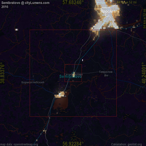
Analysis of Semibratovo night lights 2016
Square area 10x10 km:
 0%
0%90-99
0%80-89
0.91%70-79
0.45%60-69
0%50-59
0%40-49
0.91%30-39
0%20-29
0.91%10-19
0.45%0-9
96.36%Square area 50x50 km:
0.09%90-99
0.11%80-89
0.13%70-79
0.28%60-69
0.2%50-59
0.13%40-49
0.24%30-39
0.15%20-29
0.67%10-19
1.69%0-9
96.32%Clear (daylight) street map image can be seen on geolist.org.
Map coordinates:
57° 40' 56.9" North, 38° 50' 1.5" East
57° 18' 16.6" North, 39° 32' 12.8" East
56° 55' 22.2" North, 40° 14' 24" East
Some cities around Semibratovo sort by population:
• Yaroslavl
41.4 km =25.7 mi,  29°
29°
• Rostov
14.6 km =9.1 mi,  210°
210°
• Gavrilov-Yam
19 km =11.8 mi,  90°
90°
• Komsomol’sk
59 km =36.7 mi,  121°
121°
• Nekrasovskoye
64.5 km =40.1 mi,  50°
50°
• Borisoglebskiy
23.8 km =14.8 mi,  257°
257°
• Konstantinovskiy
58.5 km =36.4 mi,  3°
3°
• Petrovsk
36.5 km =22.7 mi, 206°
497242 (p: 7,511)
Sources (retrieved 2019-11-25):
» Earth at Night: Flat Maps 2012, 2016