Nekrasovskoye night lights from space
Night Light of Nekrasovskoye (Jaroslavl) from space (Russia) Src. Average luminocity for 10x10km area is 0.8261% and for 50x50km: 1.5134%.
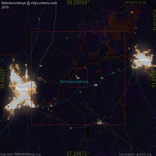
Analysis of Nekrasovskoye night lights 2016
Square area 10x10 km:
 0%
0%90-99
0%80-89
0%70-79
0%60-69
0%50-59
0%40-49
0.23%30-39
1.93%20-29
0.11%10-19
0%0-9
97.73%Square area 50x50 km:
0.14%90-99
0.22%80-89
0.11%70-79
0.13%60-69
0.23%50-59
0.06%40-49
0.28%30-39
0.53%20-29
0.86%10-19
1.11%0-9
96.33%Clear (daylight) street map image can be seen on geolist.org.
Map coordinates:
58° 3' 2.3" North, 39° 39' 45.2" East
57° 40' 35.9" North, 40° 21' 56.4" East
57° 17' 55.4" North, 41° 4' 7.7" East
Some cities around Nekrasovskoye sort by population:
• Yaroslavl
29.7 km =18.5 mi,  259°
259°
• Kostroma
34.8 km =21.6 mi,  73°
73°
• Tutayev
54.1 km =33.6 mi,  295°
295°
• Nerekhta
27.2 km =16.9 mi,  152°
152°
• Volgorechensk
54 km =33.6 mi,  119°
119°
• Gavrilov-Yam
51.7 km =32.1 mi,  216°
216°
• Krasnoye-na-Volge
55.1 km =34.2 mi,  109°
109°
• Konstantinovskiy
49.1 km =30.5 mi,  290°
290°
522799 (p: 6,353)
Sources (retrieved 2019-11-25):
» Earth at Night: Flat Maps 2012, 2016