Ivangorod night lights from space
Night Light of Ivangorod (Leningradskaya Oblast') from space (Russia) Src. Average luminocity for 10x10km area is 29.7186% and for 50x50km: 3.4436%.
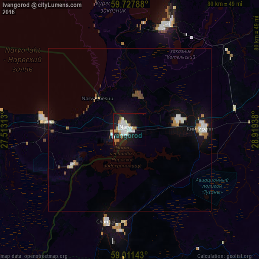
Analysis of Ivangorod night lights 2016
Square area 10x10 km:
 9.09%
9.09%90-99
7.36%80-89
2.06%70-79
2.27%60-69
3.68%50-59
0.22%40-49
0%30-39
0%20-29
9.42%10-19
30.41%0-9
35.5%Square area 50x50 km:
0.66%90-99
0.76%80-89
0.22%70-79
0.3%60-69
0.41%50-59
0.27%40-49
0.33%30-39
0.03%20-29
0.41%10-19
3.11%0-9
93.51%Clear (daylight) street map image can be seen on geolist.org.
Map coordinates:
59° 43' 40.4" North, 27° 30' 47.3" East
59° 22' 17.6" North, 28° 12' 58.5" East
59° 0' 41.1" North, 28° 55' 9.8" East
Some cities around Ivangorod sort by population:
• Narva, EE
1.6 km =1 mi,  293°
293°
• Kingisepp
22.5 km =14 mi,  89°
89°
• Kohtla-Järve, EE
53.5 km =33.2 mi,  273°
273°
• Slantsy
29.1 km =18.1 mi,  194°
194°
• Sillamäe, EE
25.8 km =16 mi,  276°
276°
• Volosovo
72.5 km =45 mi,  83°
83°
• Jõhvi, EE
45.1 km =28 mi, 268°
• Kiviõli, EE
70.6 km =43.9 mi, 268°
555624 (p: 11,074)
Sources (retrieved 2019-11-25):
» Earth at Night: Flat Maps 2012, 2016