Zolochiv night lights from space
Night Light of Zolochiv (Kharkiv) from space (Ukraine) Src. Average luminocity for 10x10km area is 0.2179% and for 50x50km: 0.9063%.
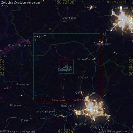
Analysis of Zolochiv night lights 2016
Square area 10x10 km:
 0%
0%90-99
0%80-89
0%70-79
0%60-69
0%50-59
0%40-49
0%30-39
0.4%20-29
0.13%10-19
0%0-9
99.47%Square area 50x50 km:
0.06%90-99
0.05%80-89
0.07%70-79
0.05%60-69
0.09%50-59
0.25%40-49
0.1%30-39
0.15%20-29
0.5%10-19
1.2%0-9
97.47%Clear (daylight) street map image can be seen on geolist.org.
Map coordinates:
50° 43' 37.4" North, 35° 16' 43.2" East
50° 16' 47.5" North, 35° 58' 54.4" East
49° 49' 42.2" North, 36° 41' 5.7" East
Some cities around Zolochiv sort by population:
• Derhachi
21.7 km =13.5 mi,  152°
152°
• Bohodukhiv
34.8 km =21.6 mi,  248°
248°
• Solonytsivka
31.7 km =19.7 mi,  173°
173°
• Mala Danylivka
27.4 km =17 mi, 151°
• Peresichna
28.4 km =17.6 mi,  180°
180°
• Slatyne
14.5 km =9 mi,  122°
122°
• Grayvoron, RU
30.7 km =19.1 mi,  315°
315°
• Golovchino, RU
31.2 km =19.4 mi,  335°
335°
686895 (p: 11,160)
Sources (retrieved 2019-11-25):
» Earth at Night: Flat Maps 2012, 2016