Prokuplje night lights from space
Night Light of Prokuplje (Central Serbia) from space (Serbia) Src. Average luminocity for 10x10km area is 11.9364% and for 50x50km: 3.4028%.
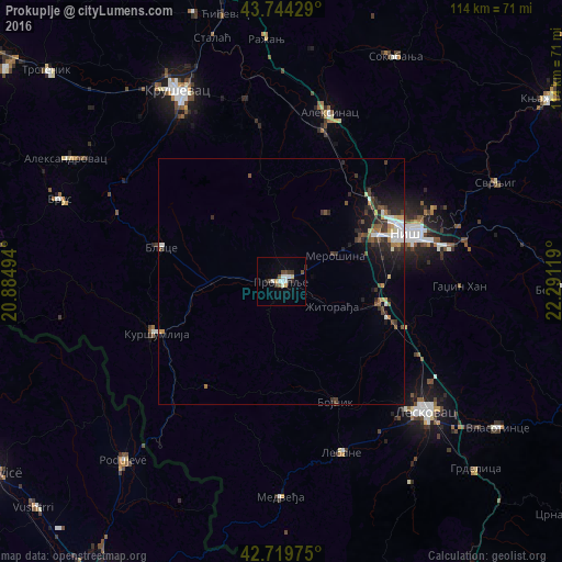
Analysis of Prokuplje night lights 2016
Square area 10x10 km:
 2.58%
2.58%90-99
2.27%80-89
0.61%70-79
1.21%60-69
0%50-59
1.06%40-49
2.58%30-39
1.82%20-29
1.52%10-19
1.36%0-9
85%Square area 50x50 km:
0.55%90-99
0.53%80-89
0.19%70-79
0.34%60-69
0.24%50-59
0.51%40-49
0.61%30-39
0.73%20-29
1.13%10-19
1.89%0-9
93.29%Clear (daylight) street map image can be seen on geolist.org.
Map coordinates:
43° 44' 39.4" North, 20° 53' 5.8" East
43° 14' 3" North, 21° 35' 17" East
42° 43' 11.1" North, 22° 17' 28.3" East
Some cities around Prokuplje sort by population:
• Niš
27.4 km =17 mi,  68°
68°
• Leskovac
39.2 km =24.4 mi,  132°
132°
• Kruševac
43.6 km =27.1 mi,  331°
331°
• Trstenik
63.6 km =39.5 mi,  311°
311°
• Podujeva, XK
48.2 km =30 mi,  221°
221°
• Vushtrri, XK
68.1 km =42.3 mi,  227°
227°
• Knjazevac
65.5 km =40.7 mi,  55°
55°
• Leposaviq, XK
65.3 km =40.6 mi,  257°
257°
786690 (p: 27,673)
Sources (retrieved 2019-11-25):
» Earth at Night: Flat Maps 2012, 2016