Bajina Bašta night lights from space
Night Light of Bajina Bašta (Central Serbia) from space (Serbia) Src. Average luminocity for 10x10km area is 7.6397% and for 50x50km: 1.7912%.
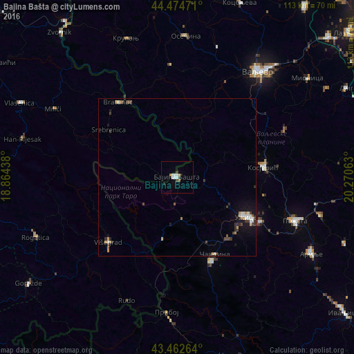
Analysis of Bajina Bašta night lights 2016
Square area 10x10 km:
 2.38%
2.38%90-99
1.43%80-89
0%70-79
0.48%60-69
1.43%50-59
0%40-49
0.79%30-39
1.11%20-29
0.48%10-19
0.79%0-9
91.11%Square area 50x50 km:
0.3%90-99
0.27%80-89
0.1%70-79
0.18%60-69
0.21%50-59
0.08%40-49
0.4%30-39
0.4%20-29
0.25%10-19
1.13%0-9
96.66%Clear (daylight) street map image can be seen on geolist.org.
Map coordinates:
44° 28' 29" North, 18° 51' 51.8" East
43° 58' 15" North, 19° 34' 3" East
43° 27' 45.5" North, 20° 16' 14.3" East
Some cities around Bajina Bašta sort by population:
• Užice
25.8 km =16 mi,  118°
118°
• Valjevo
42.9 km =26.7 mi,  37°
37°
• Goražde, BA
58.2 km =36.2 mi,  234°
234°
• Sokolac, BA
61.5 km =38.2 mi,  266°
266°
• Milići, BA
44 km =27.3 mi,  300°
300°
• Zvornik, BA
59.2 km =36.8 mi,  321°
321°
• Arilje
48.8 km =30.3 mi, 119°
• Višegrad, BA
30.4 km =18.9 mi, 226°
3204623 (p: 8,533)
Sources (retrieved 2019-11-25):
» Earth at Night: Flat Maps 2012, 2016