Arilje night lights from space
Night Light of Arilje (Central Serbia) from space (Serbia) Src. Average luminocity for 10x10km area is 9.9% and for 50x50km: 4.7334%.
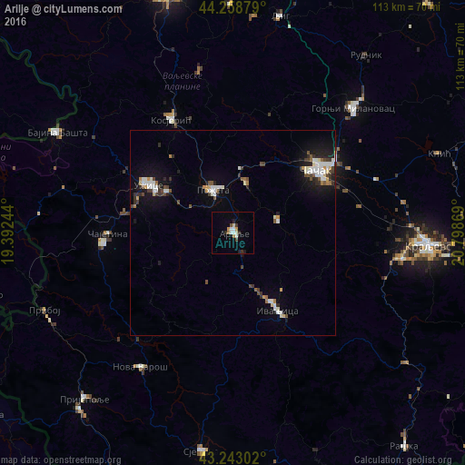
Analysis of Arilje night lights 2016
Square area 10x10 km:
 1.67%
1.67%90-99
1.82%80-89
0.76%70-79
1.21%60-69
1.21%50-59
0.61%40-49
0.61%30-39
1.36%20-29
1.82%10-19
1.67%0-9
87.27%Square area 50x50 km:
0.86%90-99
0.96%80-89
0.31%70-79
0.38%60-69
0.3%50-59
0.4%40-49
0.7%30-39
0.7%20-29
0.75%10-19
3.15%0-9
91.49%Clear (daylight) street map image can be seen on geolist.org.
Map coordinates:
44° 15' 31.6" North, 19° 23' 32.8" East
43° 45' 11" North, 20° 5' 44" East
43° 14' 34.9" North, 20° 47' 55.3" East
Some cities around Arilje sort by population:
• Čačak
25.5 km =15.8 mi,  52°
52°
• Kraljevo
47.8 km =29.7 mi,  93°
93°
• Užice
23 km =14.3 mi,  300°
300°
• Valjevo
60.2 km =37.4 mi,  344°
344°
• Gornji Milanovac
42.2 km =26.2 mi,  44°
44°
• Vrnjačka Banja
65.9 km =40.9 mi,  102°
102°
• Bajina Bašta
48.8 km =30.3 mi, 299°
• Višegrad, BA
64.6 km =40.1 mi,  272°
272°
793093 (p: 6,762)
Sources (retrieved 2019-11-25):
» Earth at Night: Flat Maps 2012, 2016