Bačka Topola night lights from space
Night Light of Bačka Topola (Vojvodina) from space (Serbia) Src. Average luminocity for 10x10km area is 10.3229% and for 50x50km: 3.2153%.
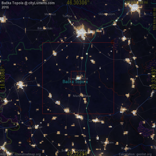
Analysis of Bačka Topola night lights 2016
Square area 10x10 km:
 1.79%
1.79%90-99
2.08%80-89
0.3%70-79
1.04%60-69
0.15%50-59
2.68%40-49
1.49%30-39
1.49%20-29
1.19%10-19
0.6%0-9
87.2%Square area 50x50 km:
0.24%90-99
0.37%80-89
0.39%70-79
0.41%60-69
0.46%50-59
0.66%40-49
0.38%30-39
0.37%20-29
0.48%10-19
0.42%0-9
95.82%Clear (daylight) street map image can be seen on geolist.org.
Map coordinates:
46° 18' 11" North, 18° 55' 43.2" East
45° 48' 54.6" North, 19° 37' 54.5" East
45° 19' 22.6" North, 20° 20' 5.7" East
Some cities around Bačka Topola sort by population:
• Subotica
31.8 km =19.8 mi,  4°
4°
• Sombor
40.5 km =25.2 mi,  263°
263°
• Vrbas
27.1 km =16.8 mi,  178°
178°
• Bečej
38.2 km =23.7 mi,  125°
125°
• Senta
36.7 km =22.8 mi,  70°
70°
• Bačko Petrovo Selo
36.7 km =22.8 mi,  109°
109°
• Mol
39.3 km =24.4 mi,  98°
98°
• Stanišić
38.5 km =23.9 mi,  290°
290°
3204672 (p: 16,154)
Sources (retrieved 2019-11-25):
» Earth at Night: Flat Maps 2012, 2016