Apatin night lights from space
Night Light of Apatin (Vojvodina) from space (Serbia) Src. Average luminocity for 10x10km area is 10.603% and for 50x50km: 5.0591%.
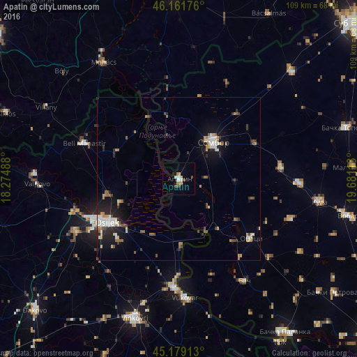
Analysis of Apatin night lights 2016
Square area 10x10 km:
 1.97%
1.97%90-99
1.67%80-89
0.45%70-79
1.82%60-69
1.36%50-59
1.06%40-49
1.36%30-39
0.61%20-29
0.61%10-19
1.97%0-9
87.12%Square area 50x50 km:
0.64%90-99
0.85%80-89
0.41%70-79
0.67%60-69
0.54%50-59
0.77%40-49
0.57%30-39
0.63%20-29
1.39%10-19
3.48%0-9
90.06%Clear (daylight) street map image can be seen on geolist.org.
Map coordinates:
46° 9' 42.3" North, 18° 16' 29.6" East
45° 40' 21.4" North, 18° 58' 40.8" East
45° 10' 44.9" North, 19° 40' 52.1" East
Some cities around Apatin sort by population:
• Osijek, HR
25.9 km =16.1 mi,  238°
238°
• Sombor
15.4 km =9.6 mi,  42°
42°
• Beli Manastir, HR
31 km =19.3 mi,  290°
290°
• Tenja, HR
26.4 km =16.4 mi,  222°
222°
• Višnjevac, HR
30.6 km =19 mi,  247°
247°
• Sonta
12.7 km =7.9 mi,  133°
133°
• Darda, HR
22.2 km =13.8 mi,  257°
257°
• Prigrevica
8.6 km =5.3 mi,  87°
87°
3204793 (p: 18,320)
Sources (retrieved 2019-11-25):
» Earth at Night: Flat Maps 2012, 2016