Tenja night lights from space
Night Light of Tenja (Osječko-Baranjska) from space (Croatia) Src. Average luminocity for 10x10km area is 13.5492% and for 50x50km: 7.769%.
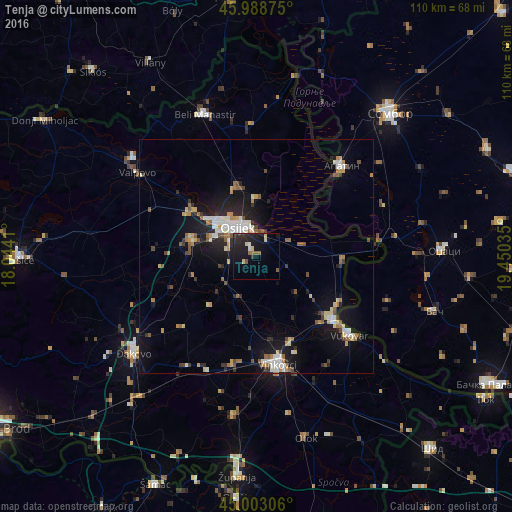
Analysis of Tenja night lights 2016
Square area 10x10 km:
 0.16%
0.16%90-99
1.27%80-89
3.02%70-79
0%60-69
1.27%50-59
2.38%40-49
0.32%30-39
1.75%20-29
9.21%10-19
19.68%0-9
60.95%Square area 50x50 km:
0.97%90-99
1.29%80-89
0.83%70-79
0.82%60-69
0.87%50-59
1.08%40-49
0.87%30-39
0.8%20-29
1.94%10-19
6.64%0-9
83.9%Clear (daylight) street map image can be seen on geolist.org.
Map coordinates:
45° 59' 19.5" North, 18° 2' 38.8" East
45° 29' 53" North, 18° 44' 50" East
45° 0' 11" North, 19° 27' 1.3" East
Some cities around Tenja sort by population:
• Osijek
7.2 km =4.5 mi,  324°
324°
• Vinkovci
23.7 km =14.7 mi,  169°
169°
• Vukovar
25.7 km =16 mi,  129°
129°
• Čepin
14.6 km =9.1 mi,  281°
281°
• Ivankovo
23.8 km =14.8 mi,  191°
191°
• Višnjevac
13 km =8.1 mi,  307°
307°
• Darda
14.9 km =9.3 mi,  345°
345°
• Borovo
21.8 km =13.5 mi, 128°
3189161 (p: 7,376)
Sources (retrieved 2019-11-25):
» Earth at Night: Flat Maps 2012, 2016