Višnjevac night lights from space
Night Light of Višnjevac (Osječko-Baranjska) from space (Croatia) Src. Average luminocity for 10x10km area is 38.4894% and for 50x50km: 5.3813%.
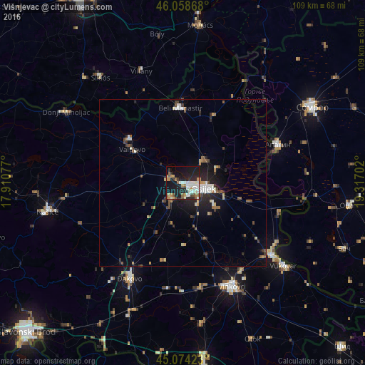
Analysis of Višnjevac night lights 2016
Square area 10x10 km:
 7.58%
7.58%90-99
9.85%80-89
2.12%70-79
5.45%60-69
3.18%50-59
4.55%40-49
2.73%30-39
2.27%20-29
14.7%10-19
33.48%0-9
14.09%Square area 50x50 km:
0.66%90-99
0.92%80-89
0.43%70-79
0.58%60-69
0.49%50-59
0.85%40-49
0.68%30-39
0.71%20-29
1.77%10-19
4.11%0-9
88.8%Clear (daylight) street map image can be seen on geolist.org.
Map coordinates:
46° 3' 31.2" North, 17° 54' 38.8" East
45° 34' 7" North, 18° 36' 50" East
45° 4' 27.2" North, 19° 19' 1.3" East
Some cities around Višnjevac sort by population:
• Osijek
6.5 km =4 mi,  107°
107°
• Apatin, RS
30.6 km =19 mi,  67°
67°
• Čepin
6.4 km =4 mi,  218°
218°
• Beli Manastir
22.4 km =13.9 mi,  357°
357°
• Valpovo
18.3 km =11.4 mi,  304°
304°
• Tenja
13 km =8.1 mi,  127°
127°
• Belišće
20.4 km =12.7 mi,  307°
307°
• Darda
9.4 km =5.8 mi,  45°
45°
3187657 (p: 6,680)
Sources (retrieved 2019-11-25):
» Earth at Night: Flat Maps 2012, 2016