Filipeştii de Târg night lights from space
Night Light of Filipeştii de Târg (Prahova) from space (Romania) Src. Average luminocity for 10x10km area is 6.2825% and for 50x50km: 7.978%.
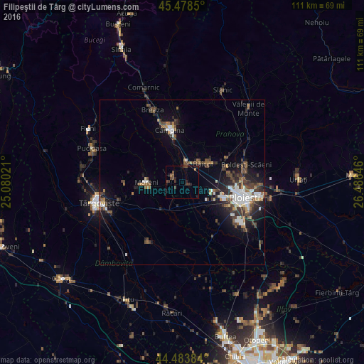
Analysis of Filipeştii de Târg night lights 2016
Square area 10x10 km:
 0%
0%90-99
0%80-89
0%70-79
0.32%60-69
0.95%50-59
0.63%40-49
3.65%30-39
2.7%20-29
2.7%10-19
3.02%0-9
86.03%Square area 50x50 km:
1.24%90-99
1.31%80-89
0.39%70-79
0.47%60-69
0.95%50-59
1.15%40-49
1.92%30-39
1.71%20-29
2.31%10-19
4.7%0-9
83.85%Clear (daylight) street map image can be seen on geolist.org.
Map coordinates:
45° 28' 42.6" North, 25° 4' 48.8" East
44° 58' 60" North, 25° 46' 60" East
44° 29' 1.8" North, 26° 29' 11.3" East
Some cities around Filipeştii de Târg sort by population:
• Moreni
10.9 km =6.8 mi,  269°
269°
• Băicoi
7.6 km =4.7 mi,  43°
43°
• Ariceştii-Rahtivani
5.4 km =3.4 mi,  133°
133°
• Dărmăneşti
7.4 km =4.6 mi,  180°
180°
• Floreşti
7.4 km =4.6 mi,  0°
0°
• Măgureni
10.1 km =6.3 mi,  337°
337°
• Scorţeni
14 km =8.7 mi,  21°
21°
• Băneşti
13 km =8.1 mi,  354°
354°
678243 (p: 7,794)
Sources (retrieved 2019-11-25):
» Earth at Night: Flat Maps 2012, 2016