Băneşti night lights from space
Night Light of Băneşti (Prahova) from space (Romania) Src. Average luminocity for 10x10km area is 15.2303% and for 50x50km: 7.6964%.
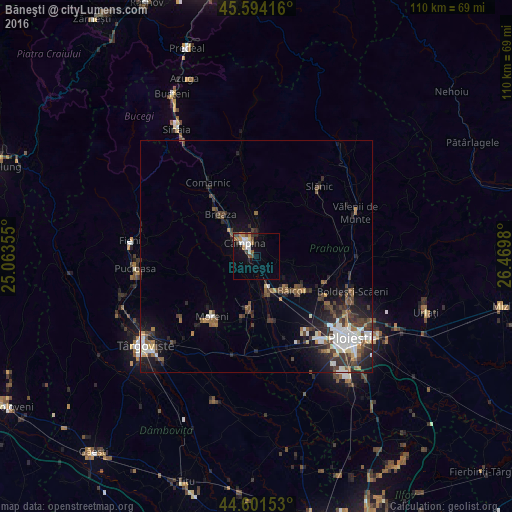
Analysis of Băneşti night lights 2016
Square area 10x10 km:
 2.73%
2.73%90-99
2.73%80-89
0.61%70-79
1.67%60-69
3.18%50-59
0.61%40-49
3.94%30-39
0.76%20-29
1.82%10-19
5.76%0-9
76.21%Square area 50x50 km:
1.26%90-99
1.32%80-89
0.41%70-79
0.52%60-69
0.86%50-59
1.05%40-49
1.74%30-39
1.67%20-29
2.34%10-19
4.12%0-9
84.72%Clear (daylight) street map image can be seen on geolist.org.
Map coordinates:
45° 35' 39" North, 25° 3' 48.8" East
45° 6' 0" North, 25° 46' 0" East
44° 36' 5.5" North, 26° 28' 11.3" East
Some cities around Băneşti sort by population:
• Câmpina
3.8 km =2.4 mi,  319°
319°
• Brebu Mânăstirei
9.3 km =5.8 mi,  0°
0°
• Floreşti
5.7 km =3.5 mi,  166°
166°
• Doftana
6.1 km =3.8 mi,  25°
25°
• Măgureni
4.5 km =2.8 mi,  215°
215°
• Telega
3.9 km =2.4 mi,  19°
19°
• Scorţeni
6.5 km =4 mi,  90°
90°
• Poiana Câmpina
7.5 km =4.7 mi,  299°
299°
685462 (p: 5,636)
Sources (retrieved 2019-11-25):
» Earth at Night: Flat Maps 2012, 2016