Ariceştii-Rahtivani night lights from space
Night Light of Ariceştii-Rahtivani (Prahova) from space (Romania) Src. Average luminocity for 10x10km area is 4.6444% and for 50x50km: 7.7604%.
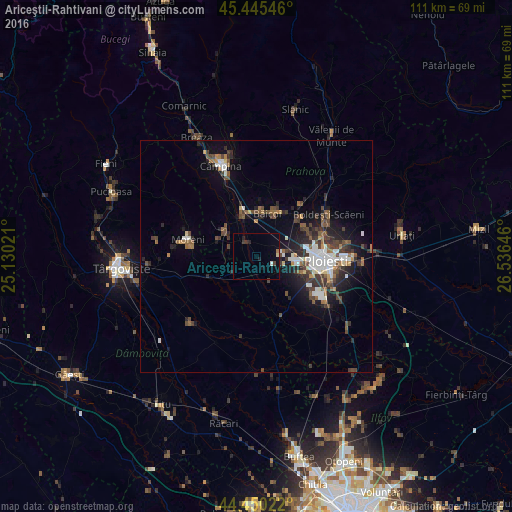
Analysis of Ariceştii-Rahtivani night lights 2016
Square area 10x10 km:
 0.48%
0.48%90-99
0.16%80-89
0.63%70-79
0%60-69
0.63%50-59
0%40-49
0.79%30-39
1.11%20-29
1.27%10-19
2.06%0-9
92.86%Square area 50x50 km:
1.21%90-99
1.31%80-89
0.38%70-79
0.44%60-69
0.9%50-59
1.09%40-49
1.84%30-39
1.65%20-29
2.34%10-19
4.45%0-9
84.39%Clear (daylight) street map image can be seen on geolist.org.
Map coordinates:
45° 26' 43.7" North, 25° 7' 48.8" East
44° 57' 0" North, 25° 49' 60" East
44° 27' 0.8" North, 26° 32' 11.3" East
Some cities around Ariceştii-Rahtivani sort by population:
• Băicoi
9.4 km =5.8 mi,  8°
8°
• Filipeştii de Pădure
8.6 km =5.3 mi,  310°
310°
• Târgşoru Vechi
11.4 km =7.1 mi,  144°
144°
• Dărmăneşti
5.4 km =3.4 mi,  226°
226°
• Filipeştii de Târg
5.4 km =3.4 mi, 313°
• Floreşti
11.8 km =7.3 mi,  340°
340°
• Măneşti
9.4 km =5.8 mi,  171°
171°
• Păuleşti
13 km =8.1 mi,  64°
64°
686175 (p: 8,764)
Sources (retrieved 2019-11-25):
» Earth at Night: Flat Maps 2012, 2016