Dărmăneşti night lights from space
Night Light of Dărmăneşti (Dâmboviţa) from space (Romania) Src. Average luminocity for 10x10km area is 0.4619% and for 50x50km: 7.8069%.
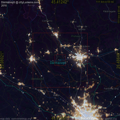
Analysis of Dărmăneşti night lights 2016
Square area 10x10 km:
 0%
0%90-99
0%80-89
0%70-79
0%60-69
0%50-59
0%40-49
0%30-39
0%20-29
0.79%10-19
0.48%0-9
98.73%Square area 50x50 km:
1.26%90-99
1.33%80-89
0.4%70-79
0.42%60-69
0.88%50-59
1.12%40-49
1.83%30-39
1.72%20-29
2.2%10-19
4.61%0-9
84.24%Clear (daylight) street map image can be seen on geolist.org.
Map coordinates:
45° 24' 44.7" North, 25° 4' 48.8" East
44° 55' 0" North, 25° 46' 60" East
44° 24' 59.8" North, 26° 29' 11.3" East
Some cities around Dărmăneşti sort by population:
• Moreni
13.2 km =8.2 mi,  303°
303°
• Băicoi
14 km =8.7 mi,  22°
22°
• Filipeştii de Pădure
9.6 km =6 mi,  344°
344°
• Ariceştii-Rahtivani
5.4 km =3.4 mi,  46°
46°
• Târgşoru Vechi
11.9 km =7.4 mi,  117°
117°
• Filipeştii de Târg
7.4 km =4.6 mi,  0°
0°
• Măneşti
7.6 km =4.7 mi,  136°
136°
• Bucşani
11.9 km =7.4 mi,  242°
242°
679726 (p: 7,919)
Sources (retrieved 2019-11-25):
» Earth at Night: Flat Maps 2012, 2016