Scorţeni night lights from space
Night Light of Scorţeni (Prahova) from space (Romania) Src. Average luminocity for 10x10km area is 1.1833% and for 50x50km: 7.255%.
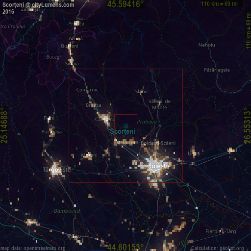
Analysis of Scorţeni night lights 2016
Square area 10x10 km:
100  0%
0%
90-99 0%
80-89 0%
70-79 0%
60-69 0%
50-59 0%
40-49 0%
30-39 0%
20-29 0%
10-19 0.61%
0-9 99.39%
0%90-99
0%80-89
0%70-79
0%60-69
0%50-59
0%40-49
0%30-39
0%20-29
0%10-19
0.61%0-9
99.39%Square area 50x50 km:
100 1.12%
90-99 1.2%
80-89 0.37%
70-79 0.45%
60-69 0.87%
50-59 1.04%
40-49 1.7%
30-39 1.58%
20-29 2.37%
10-19 3.8%
0-9 85.5%
1.12%90-99
1.2%80-89
0.37%70-79
0.45%60-69
0.87%50-59
1.04%40-49
1.7%30-39
1.58%20-29
2.37%10-19
3.8%0-9
85.5%Clear (daylight) street map image can be seen on geolist.org.
Map coordinates:
45° 35' 39" North, 25° 8' 48.8" East
45° 6' 0" North, 25° 51' 0" East
44° 36' 5.5" North, 26° 33' 11.3" East
Some cities around Scorţeni sort by population:
• Câmpina
9.5 km =5.9 mi,  287°
287°
• Băicoi
7.4 km =4.6 mi,  180°
180°
• Plopeni
9.8 km =6.1 mi,  125°
125°
• Floreşti
7.6 km =4.7 mi,  223°
223°
• Doftana
6.8 km =4.2 mi,  324°
324°
• Măgureni
9.9 km =6.2 mi,  247°
247°
• Telega
6.4 km =4 mi,  305°
305°
• Băneşti
6.5 km =4 mi,  270°
270°
667586 (p: 5,995)
Sources (retrieved 2019-11-25):
» Earth at Night: Flat Maps 2012, 2016