Măgureni night lights from space
Night Light of Măgureni (Prahova) from space (Romania) Src. Average luminocity for 10x10km area is 5.7833% and for 50x50km: 8.0821%.
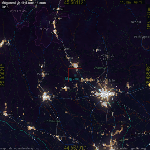
Analysis of Măgureni night lights 2016
Square area 10x10 km:
 0%
0%90-99
0.61%80-89
0.61%70-79
0%60-69
0%50-59
1.06%40-49
2.42%30-39
0.15%20-29
0.61%10-19
3.64%0-9
90.91%Square area 50x50 km:
1.32%90-99
1.35%80-89
0.4%70-79
0.62%60-69
0.99%50-59
1.09%40-49
1.76%30-39
1.56%20-29
2.21%10-19
4.83%0-9
83.86%Clear (daylight) street map image can be seen on geolist.org.
Map coordinates:
45° 33' 40" North, 25° 1' 48.8" East
45° 4' 0" North, 25° 43' 60" East
44° 34' 4.5" North, 26° 26' 11.3" East
Some cities around Măgureni sort by population:
• Câmpina
6.6 km =4.1 mi,  1°
1°
• Băicoi
9.9 km =6.2 mi,  112°
112°
• Filipeştii de Pădure
7.5 km =4.7 mi,  169°
169°
• Floreşti
4.3 km =2.7 mi,  115°
115°
• Telega
8.4 km =5.2 mi,  27°
27°
• Scorţeni
9.9 km =6.2 mi,  67°
67°
• Băneşti
4.5 km =2.8 mi,  35°
35°
• Poiana Câmpina
8.4 km =5.2 mi,  332°
332°
674105 (p: 6,515)
Sources (retrieved 2019-11-25):
» Earth at Night: Flat Maps 2012, 2016