Fântânele night lights from space
Night Light of Fântânele (Arad) from space (Romania) Src. Average luminocity for 10x10km area is 17.3324% and for 50x50km: 4.9983%.
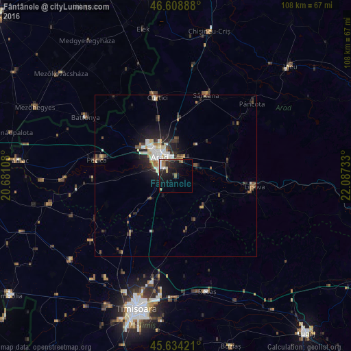
Analysis of Fântânele night lights 2016
Square area 10x10 km:
100  2.56%
2.56%
90-99 3.84%
80-89 1.7%
70-79 0.57%
60-69 1.7%
50-59 2.27%
40-49 1.14%
30-39 1.42%
20-29 8.1%
10-19 17.33%
0-9 59.38%
2.56%90-99
3.84%80-89
1.7%70-79
0.57%60-69
1.7%50-59
2.27%40-49
1.14%30-39
1.42%20-29
8.1%10-19
17.33%0-9
59.38%Square area 50x50 km:
100 0.75%
90-99 1.04%
80-89 0.53%
70-79 0.36%
60-69 0.46%
50-59 0.74%
40-49 0.56%
30-39 0.59%
20-29 1.91%
10-19 3.14%
0-9 89.92%
0.75%90-99
1.04%80-89
0.53%70-79
0.36%60-69
0.46%50-59
0.74%40-49
0.56%30-39
0.59%20-29
1.91%10-19
3.14%0-9
89.92%Clear (daylight) street map image can be seen on geolist.org.
Map coordinates:
46° 36' 32" North, 20° 40' 51.9" East
46° 7' 25.3" North, 21° 23' 3.1" East
45° 38' 3.2" North, 22° 5' 14.4" East
Some cities around Fântânele sort by population:
• Arad
8.4 km =5.2 mi,  321°
321°
• Pecica
24.9 km =15.5 mi,  281°
281°
• Lipova
24.3 km =15.1 mi,  98°
98°
• Vladimirescu
4.9 km =3 mi,  15°
15°
• Curtici
26 km =16.2 mi,  345°
345°
• Şiria
24.9 km =15.5 mi,  50°
50°
• Vinga
18.5 km =11.5 mi,  230°
230°
• Felnac
18.1 km =11.2 mi,  267°
267°
678162 (p: 5,597)
Sources (retrieved 2019-11-25):
» Earth at Night: Flat Maps 2012, 2016