Pecica night lights from space
Night Light of Pecica (Arad) from space (Romania) Src. Average luminocity for 10x10km area is 6.5114% and for 50x50km: 5.0549%.
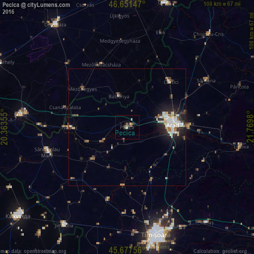
Analysis of Pecica night lights 2016
Square area 10x10 km:
 0%
0%90-99
0.99%80-89
0.99%70-79
0.57%60-69
0.57%50-59
2.27%40-49
1.7%30-39
0.14%20-29
2.13%10-19
0.85%0-9
89.77%Square area 50x50 km:
0.77%90-99
1.04%80-89
0.53%70-79
0.34%60-69
0.59%50-59
0.69%40-49
0.54%30-39
0.76%20-29
1.87%10-19
2.85%0-9
90.01%Clear (daylight) street map image can be seen on geolist.org.
Map coordinates:
46° 39' 5.3" North, 20° 21' 48.8" East
46° 10' 0" North, 21° 4' 0" East
45° 40' 39.2" North, 21° 46' 11.3" East
Some cities around Pecica sort by population:
• Arad
19.3 km =12 mi,  84°
84°
• Battonya, HU
13.5 km =8.4 mi,  343°
343°
• Periam
20.1 km =12.5 mi,  229°
229°
• Vinga
19.6 km =12.2 mi,  148°
148°
• Variaş
19 km =11.8 mi,  208°
208°
• Sânpetru Mare
23.4 km =14.5 mi, 234°
• Secusigiu
11.3 km =7 mi, 214°
• Felnac
8.5 km =5.3 mi,  130°
130°
668552 (p: 12,804)
Sources (retrieved 2019-11-25):
» Earth at Night: Flat Maps 2012, 2016