Ypacarai night lights from space
Night Light of Ypacarai (Central) from space (Paraguay) Src. Average luminocity for 10x10km area is 46.746% and for 50x50km: 34.1375%.
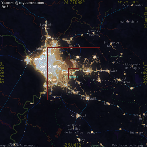
Analysis of Ypacarai night lights 2016
Square area 10x10 km:
 0.99%
0.99%90-99
1.39%80-89
7.74%70-79
9.52%60-69
16.87%50-59
10.71%40-49
11.71%30-39
7.94%20-29
16.67%10-19
15.48%0-9
0.99%Square area 50x50 km:
5.41%90-99
4.68%80-89
5.31%70-79
5.84%60-69
7.92%50-59
3.97%40-49
4.44%30-39
4.35%20-29
6.39%10-19
13.2%0-9
38.49%Clear (daylight) street map image can be seen on geolist.org.
Map coordinates:
24° 46' 15.6" South, 57° 59' 31.3" West
25° 24' 28" South, 57° 17' 20" West
26° 2' 28.3" South, 56° 35' 8.8" West
Some cities around Ypacarai sort by population:
• San Lorenzo
23.4 km =14.5 mi,  288°
288°
• Capiatá
16.8 km =10.4 mi, 290°
• Itauguá
6.8 km =4.2 mi,  284°
284°
• Caacupé
14.9 km =9.3 mi,  80°
80°
• Itá
13 km =8.1 mi,  217°
217°
• Areguá
14.3 km =8.9 mi,  317°
317°
• Guarambaré
19.1 km =11.9 mi,  241°
241°
• Yaguarón
17.1 km =10.6 mi,  178°
178°
3436585 (p: 9,655)
Sources (retrieved 2019-11-25):
» Earth at Night: Flat Maps 2012, 2016