Itá night lights from space
Night Light of Itá (Central) from space (Paraguay) Src. Average luminocity for 10x10km area is 53.2024% and for 50x50km: 34.1372%.
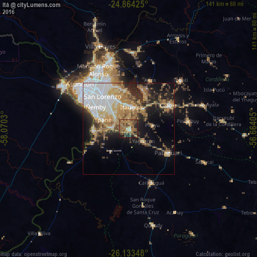
Analysis of Itá night lights 2016
Square area 10x10 km:
100  1.79%
1.79%
90-99 2.18%
80-89 6.94%
70-79 8.53%
60-69 25.2%
50-59 14.68%
40-49 13.69%
30-39 7.34%
20-29 14.09%
10-19 5.56%
0-9 0%
1.79%90-99
2.18%80-89
6.94%70-79
8.53%60-69
25.2%50-59
14.68%40-49
13.69%30-39
7.34%20-29
14.09%10-19
5.56%0-9
0%Square area 50x50 km:
100 8.58%
90-99 4.46%
80-89 4.78%
70-79 4.77%
60-69 7.03%
50-59 3.65%
40-49 4.28%
30-39 3.97%
20-29 5.96%
10-19 11.07%
0-9 41.46%
8.58%90-99
4.46%80-89
4.78%70-79
4.77%60-69
7.03%50-59
3.65%40-49
4.28%30-39
3.97%20-29
5.96%10-19
11.07%0-9
41.46%Clear (daylight) street map image can be seen on geolist.org.
Map coordinates:
24° 51' 51.3" South, 58° 4' 13.1" West
25° 30' 1.9" South, 57° 22' 1.8" West
26° 8' 0.5" South, 56° 39' 50.6" West
Some cities around Itá sort by population:
• Capiatá
18 km =11.2 mi,  334°
334°
• Nemby
20.6 km =12.8 mi,  304°
304°
• Itauguá
12.1 km =7.5 mi,  6°
6°
• San Antonio
20.1 km =12.5 mi, 295°
• Areguá
21 km =13 mi,  355°
355°
• Ypacarai
13 km =8.1 mi,  37°
37°
• Guarambaré
8.9 km =5.5 mi,  276°
276°
• Yaguarón
10.8 km =6.7 mi,  128°
128°
3437954 (p: 18,459)
Sources (retrieved 2019-11-25):
» Earth at Night: Flat Maps 2012, 2016