Areguá night lights from space
Night Light of Areguá (Central) from space (Paraguay) Src. Average luminocity for 10x10km area is 53.6587% and for 50x50km: 43.9377%.
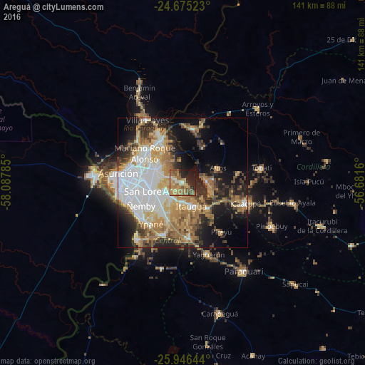
Analysis of Areguá night lights 2016
Square area 10x10 km:
 1.59%
1.59%90-99
6.35%80-89
8.93%70-79
13.29%60-69
23.21%50-59
8.53%40-49
5.16%30-39
3.37%20-29
14.48%10-19
13.69%0-9
1.39%Square area 50x50 km:
11.26%90-99
6.85%80-89
6.06%70-79
6.6%60-69
8.59%50-59
4.21%40-49
4.88%30-39
4.6%20-29
8.07%10-19
11.95%0-9
26.95%Clear (daylight) street map image can be seen on geolist.org.
Map coordinates:
24° 40' 30.8" South, 58° 5' 16.3" West
25° 18' 45" South, 57° 23' 5" West
25° 56' 47.2" South, 56° 40' 53.8" West
Some cities around Areguá sort by population:
• San Lorenzo
12.8 km =8 mi,  256°
256°
• Capiatá
7.7 km =4.8 mi,  232°
232°
• Fernando de la Mora
14.1 km =8.8 mi, 258°
• Nemby
17.7 km =11 mi,  238°
238°
• Mariano Roque Alonso
18.8 km =11.7 mi,  308°
308°
• Itauguá
9.4 km =5.8 mi,  161°
161°
• Ypacarai
14.3 km =8.9 mi,  137°
137°
• Emboscada
18.4 km =11.4 mi,  10°
10°
3439403 (p: 11,222)
Sources (retrieved 2019-11-25):
» Earth at Night: Flat Maps 2012, 2016