Valongo night lights from space
Night Light of Valongo (Aveiro) from space (Portugal) Src. Average luminocity for 10x10km area is 36.1412% and for 50x50km: 25.7557%.
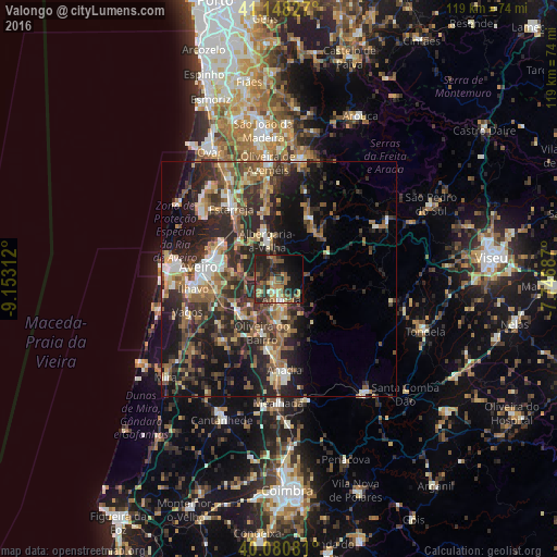
Analysis of Valongo night lights 2016
Square area 10x10 km:
 1.3%
1.3%90-99
2.44%80-89
3.25%70-79
5.03%60-69
9.74%50-59
7.79%40-49
6.33%30-39
11.36%20-29
20.78%10-19
19.97%0-9
12.01%Square area 50x50 km:
1.77%90-99
3.5%80-89
2.84%70-79
2.96%60-69
4.53%50-59
5.51%40-49
4.16%30-39
6.79%20-29
13.08%10-19
13.81%0-9
41.05%Clear (daylight) street map image can be seen on geolist.org.
Map coordinates:
41° 8' 53.8" North, 9° 9' 11.2" West
40° 37' 0" North, 8° 27' 0" West
40° 4' 50.9" North, 7° 44' 48.7" West
Some cities around Valongo sort by population:
• Aveiro
16.8 km =10.4 mi,  280°
280°
• Esgueira
15.6 km =9.7 mi, 283°
• Águeda
4.4 km =2.7 mi,  173°
173°
• Albergaria-a-Velha
8.9 km =5.5 mi,  343°
343°
• Aradas
16.2 km =10.1 mi,  271°
271°
• Oiã
11.1 km =6.9 mi,  222°
222°
• Oliveira do Bairro
11.9 km =7.4 mi,  198°
198°
• Eixo
10.1 km =6.3 mi, 276°
2732980 (p: 5,085)
Sources (retrieved 2019-11-25):
» Earth at Night: Flat Maps 2012, 2016