Águeda night lights from space
Night Light of Águeda (Aveiro) from space (Portugal) Src. Average luminocity for 10x10km area is 46.2922% and for 50x50km: 24.5625%.
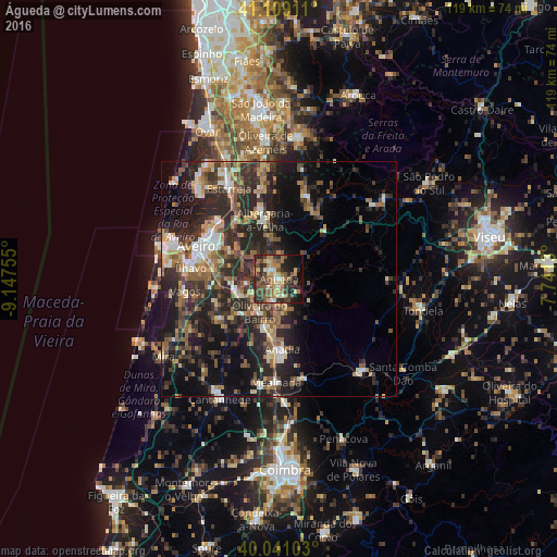
Analysis of Águeda night lights 2016
Square area 10x10 km:
 1.46%
1.46%90-99
5.03%80-89
6.98%70-79
6.98%60-69
12.99%50-59
9.9%40-49
9.09%30-39
14.94%20-29
13.96%10-19
14.61%0-9
4.06%Square area 50x50 km:
1.85%90-99
3.33%80-89
2.65%70-79
2.8%60-69
4.11%50-59
4.98%40-49
3.75%30-39
6.33%20-29
12.47%10-19
14.42%0-9
43.3%Clear (daylight) street map image can be seen on geolist.org.
Map coordinates:
41° 6' 32.8" North, 9° 8' 51.2" West
40° 34' 37.9" North, 8° 26' 39.9" West
40° 2' 27.7" North, 7° 44' 28.7" West
Some cities around Águeda sort by population:
• Esgueira
17.5 km =10.9 mi,  297°
297°
• Albergaria-a-Velha
13.2 km =8.2 mi,  346°
346°
• Aradas
17.4 km =10.8 mi,  286°
286°
• Oiã
8.8 km =5.5 mi,  244°
244°
• Arcos
14.4 km =8.9 mi,  179°
179°
• Oliveira do Bairro
8.1 km =5 mi,  210°
210°
• Eixo
11.9 km =7.4 mi, 297°
• Valongo
4.4 km =2.7 mi, 353°
2743292 (p: 11,941)
Sources (retrieved 2019-11-25):
» Earth at Night: Flat Maps 2012, 2016