Valbom night lights from space
Night Light of Valbom (Porto) from space (Portugal) Src. Average luminocity for 10x10km area is 97.2971% and for 50x50km: 49.9751%.
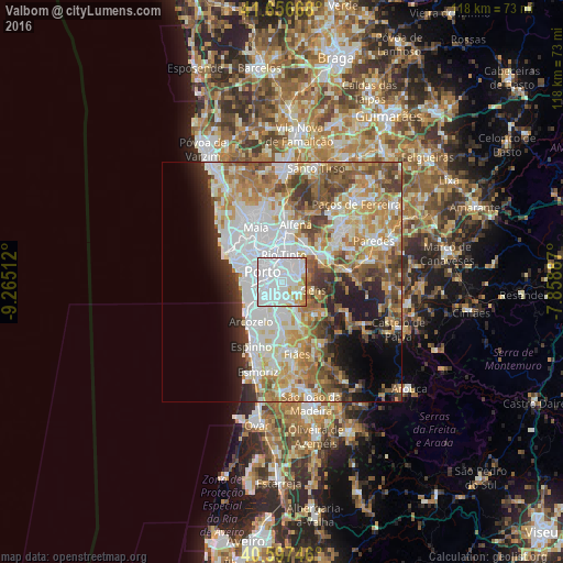
Analysis of Valbom night lights 2016
Square area 10x10 km:
 73.38%
90-99
16.4%80-89
4.38%70-79
4.87%60-69
0.97%50-59
0%40-49
0%30-39
0%20-29
0%10-19
0%0-9
0%Square area 50x50 km:
14.22%90-99
10.8%80-89
5.48%70-79
7.79%60-69
8.2%50-59
5.69%40-49
5.14%30-39
4.71%20-29
5.35%10-19
6.77%0-9
25.86%Clear (daylight) street map image can be seen on geolist.org.
Map coordinates:
41° 39' 24" North, 9° 15' 54.4" West
41° 7' 45.2" North, 8° 33' 43.2" West
40° 35' 50.9" North, 7° 51' 31.9" West
Some cities around Valbom sort by population:
• Porto
4.7 km =2.9 mi,  298°
298°
• Vila Nova de Gaia
4.3 km =2.7 mi,  262°
262°
• Gondomar
3 km =1.9 mi,  55°
55°
• Oliveira do Douro
2 km =1.2 mi, 255°
• Fânzeres
5 km =3.1 mi,  32°
32°
• Vilar de Andorinho
3.3 km =2.1 mi,  217°
217°
• Avintes
2.6 km =1.6 mi,  159°
159°
• Jovim
4.1 km =2.5 mi,  119°
119°
2733249 (p: 14,443)
Sources (retrieved 2019-11-25):
» Earth at Night: Flat Maps 2012, 2016