Santa Comba Dão night lights from space
Night Light of Santa Comba Dão (Viseu) from space (Portugal) Src. Average luminocity for 10x10km area is 2.9133% and for 50x50km: 11.4424%.
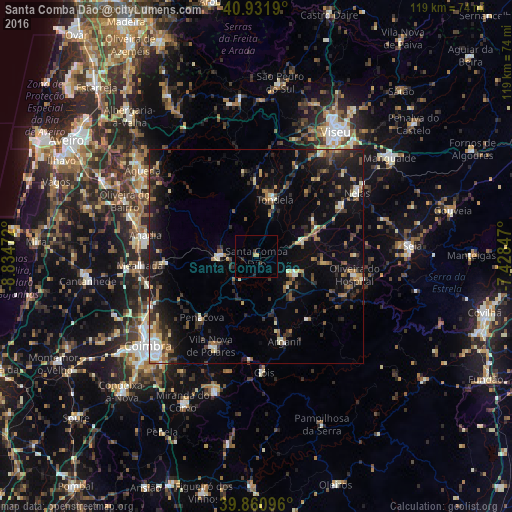
Analysis of Santa Comba Dão night lights 2016
Square area 10x10 km:
 0%
0%90-99
0%80-89
0.68%70-79
0.68%60-69
0%50-59
0%40-49
0%30-39
1.53%20-29
1.19%10-19
0%0-9
95.92%Square area 50x50 km:
0.78%90-99
1.22%80-89
1.15%70-79
0.93%60-69
1.49%50-59
2.03%40-49
1.68%30-39
2.53%20-29
3.94%10-19
9.69%0-9
74.57%Clear (daylight) street map image can be seen on geolist.org.
Map coordinates:
40° 55' 54.8" North, 8° 50' 5" West
40° 23' 54.8" North, 8° 7' 53.8" West
39° 51' 39.5" North, 7° 25' 42.5" West
Some cities around Santa Comba Dão sort by population:
• Coimbra
32.5 km =20.2 mi,  228°
228°
• Santo António dos Olivais
30.7 km =19.1 mi, 229°
• Tábua
9.6 km =6 mi,  115°
115°
• Lousã
32.9 km =20.4 mi,  197°
197°
• Tondela
13.8 km =8.6 mi,  18°
18°
• Arcos
26.8 km =16.7 mi,  281°
281°
• Carregal do Sal
11.8 km =7.3 mi,  70°
70°
• Poiares
23.5 km =14.6 mi,  207°
207°
2734747 (p: 11,597)
Sources (retrieved 2019-11-25):
» Earth at Night: Flat Maps 2012, 2016