Tondela night lights from space
Night Light of Tondela (Viseu) from space (Portugal) Src. Average luminocity for 10x10km area is 17.6735% and for 50x50km: 13.0469%.
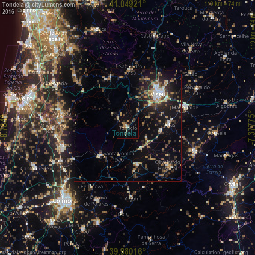
Analysis of Tondela night lights 2016
Square area 10x10 km:
 0.85%
0.85%90-99
1.7%80-89
2.21%70-79
1.87%60-69
3.74%50-59
1.7%40-49
4.25%30-39
2.21%20-29
4.25%10-19
10.88%0-9
66.33%Square area 50x50 km:
0.99%90-99
1.58%80-89
1.08%70-79
1.43%60-69
1.81%50-59
2.13%40-49
2%30-39
2.8%20-29
4.71%10-19
9.73%0-9
71.75%Clear (daylight) street map image can be seen on geolist.org.
Map coordinates:
41° 2' 57.2" North, 8° 47' 2.4" West
40° 31' 0.6" North, 8° 4' 51.1" West
39° 58' 48.6" North, 7° 22' 39.9" West
Some cities around Tondela sort by population:
• Viseu
21.6 km =13.4 mi,  42°
42°
• Tábua
17.8 km =11.1 mi,  165°
165°
• Águeda
31.4 km =19.5 mi,  282°
282°
• Santa Comba Dão
13.8 km =8.6 mi,  198°
198°
• Rio de Loba
23.9 km =14.9 mi,  45°
45°
• Abraveses
22.7 km =14.1 mi, 36°
• Mangualde
28.7 km =17.8 mi,  70°
70°
• Carregal do Sal
11.5 km =7.1 mi,  143°
143°
2733533 (p: 8,800)
Sources (retrieved 2019-11-25):
» Earth at Night: Flat Maps 2012, 2016