Arcos night lights from space
Night Light of Arcos (Aveiro) from space (Portugal) Src. Average luminocity for 10x10km area is 41.3503% and for 50x50km: 22.3037%.
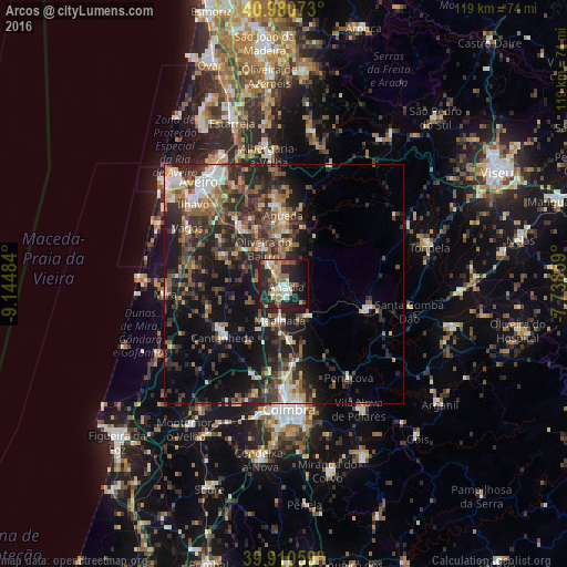
Analysis of Arcos night lights 2016
Square area 10x10 km:
 2.72%
2.72%90-99
9.18%80-89
6.12%70-79
4.93%60-69
6.29%50-59
8.5%40-49
2.21%30-39
3.74%20-29
27.04%10-19
22.45%0-9
6.8%Square area 50x50 km:
1.93%90-99
2.86%80-89
2.48%70-79
1.94%60-69
3.47%50-59
4.64%40-49
3.48%30-39
6.19%20-29
10.58%10-19
13.87%0-9
48.57%Clear (daylight) street map image can be seen on geolist.org.
Map coordinates:
40° 58' 50.6" North, 9° 8' 41.4" West
40° 26' 52" North, 8° 26' 30.2" West
39° 54' 38.1" North, 7° 44' 18.9" West
Some cities around Arcos sort by population:
• Águeda
14.4 km =8.9 mi,  359°
359°
• Mira
25.1 km =15.6 mi,  265°
265°
• Cantanhede
17.1 km =10.6 mi,  228°
228°
• Oiã
13.4 km =8.3 mi,  322°
322°
• Oliveira do Bairro
8.6 km =5.3 mi,  329°
329°
• Eixo
22.7 km =14.1 mi, 331°
• Arazede
25.2 km =15.7 mi,  224°
224°
• Valongo
18.8 km =11.7 mi, 357°
2742811 (p: 6,725)
Sources (retrieved 2019-11-25):
» Earth at Night: Flat Maps 2012, 2016