Ramada night lights from space
Night Light of Ramada (Lisbon) from space (Portugal) Src. Average luminocity for 10x10km area is 93.6616% and for 50x50km: 54.6179%.
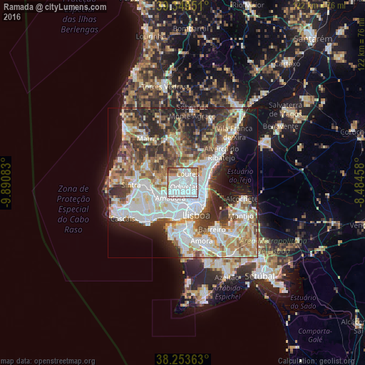
Analysis of Ramada night lights 2016
Square area 10x10 km:
 63.44%
90-99
19.05%80-89
1.7%70-79
6.63%60-69
4.25%50-59
2.38%40-49
2.38%30-39
0.17%20-29
0%10-19
0%0-9
0%Square area 50x50 km:
15.47%90-99
12.81%80-89
5.25%70-79
5.4%60-69
7.79%50-59
6.49%40-49
6.31%30-39
8.02%20-29
10.69%10-19
8.53%0-9
13.24%Clear (daylight) street map image can be seen on geolist.org.
Map coordinates:
39° 20' 58.2" North, 9° 53' 27" West
38° 48' 13.2" North, 9° 11' 15.7" West
38° 15' 13.1" North, 8° 29' 4.5" West
Some cities around Ramada sort by population:
• Loures
3.5 km =2.2 mi,  28°
28°
• Odivelas
1.3 km =0.8 mi,  164°
164°
• Pontinha
4.1 km =2.5 mi,  194°
194°
• Póvoa de Santo Adrião
1.9 km =1.2 mi,  102°
102°
• Caneças
3.5 km =2.2 mi,  287°
287°
• Charneca
4.4 km =2.7 mi,  120°
120°
• Famões
2.6 km =1.6 mi,  228°
228°
• Olival do Basto
2.3 km =1.4 mi,  127°
127°
2264087 (p: 17,535)
Sources (retrieved 2019-11-25):
» Earth at Night: Flat Maps 2012, 2016