Olival do Basto night lights from space
Night Light of Olival do Basto (Lisbon) from space (Portugal) Src. Average luminocity for 10x10km area is 97.835% and for 50x50km: 54.891%.
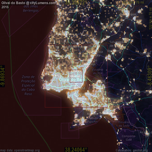
Analysis of Olival do Basto night lights 2016
Square area 10x10 km:
 78.74%
90-99
14.29%80-89
1.53%70-79
3.91%60-69
0.68%50-59
0.51%40-49
0.34%30-39
0%20-29
0%10-19
0%0-9
0%Square area 50x50 km:
15.65%90-99
12.98%80-89
5.37%70-79
5.47%60-69
7.86%50-59
6.75%40-49
6.22%30-39
7.74%20-29
9.91%10-19
7.97%0-9
14.08%Clear (daylight) street map image can be seen on geolist.org.
Map coordinates:
39° 20' 12.2" North, 9° 52' 9.6" West
38° 47' 26.8" North, 9° 9' 58.4" West
38° 14' 26.3" North, 8° 27' 47.1" West
Some cities around Olival do Basto sort by population:
• Odivelas
1.5 km =0.9 mi,  277°
277°
• Camarate
3.6 km =2.2 mi,  66°
66°
• Ramada
2.3 km =1.4 mi,  307°
307°
• Póvoa de Santo Adrião
1 km =0.6 mi,  357°
357°
• Charneca
2.1 km =1.3 mi,  112°
112°
• Famões
3.8 km =2.4 mi,  265°
265°
• Apelação
3.9 km =2.4 mi,  48°
48°
• Prior Velho
3.9 km =2.4 mi,  88°
88°
2265422 (p: 5,959)
Sources (retrieved 2019-11-25):
» Earth at Night: Flat Maps 2012, 2016