Charneca night lights from space
Night Light of Charneca (Lisbon) from space (Portugal) Src. Average luminocity for 10x10km area is 97.4915% and for 50x50km: 54.3912%.
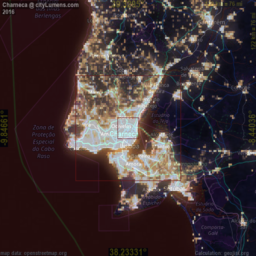
Analysis of Charneca night lights 2016
Square area 10x10 km:
 78.57%
90-99
15.82%80-89
0.34%70-79
1.19%60-69
0.68%50-59
2.55%40-49
0.85%30-39
0%20-29
0%10-19
0%0-9
0%Square area 50x50 km:
15.62%90-99
13%80-89
5.23%70-79
5.54%60-69
7.78%50-59
6.67%40-49
6.16%30-39
7.27%20-29
9.35%10-19
7.58%0-9
15.79%Clear (daylight) street map image can be seen on geolist.org.
Map coordinates:
39° 19' 46.2" North, 9° 50' 47.8" West
38° 47' 0.6" North, 9° 8' 36.5" West
38° 13' 59.9" North, 8° 26' 25.3" West
Some cities around Charneca sort by population:
• Olivais
3.5 km =2.2 mi,  115°
115°
• Alvalade
3.4 km =2.1 mi,  180°
180°
• Camarate
2.6 km =1.6 mi,  30°
30°
• Sacavém
3.2 km =2 mi,  72°
72°
• Póvoa de Santo Adrião
2.7 km =1.7 mi,  312°
312°
• Apelação
3.5 km =2.2 mi,  16°
16°
• Prior Velho
2.1 km =1.3 mi,  64°
64°
• Olival do Basto
2.1 km =1.3 mi,  292°
292°
2269280 (p: 10,509)
Sources (retrieved 2019-11-25):
» Earth at Night: Flat Maps 2012, 2016