Merelim night lights from space
Night Light of Merelim (Braga) from space (Portugal) Src. Average luminocity for 10x10km area is 76.6282% and for 50x50km: 44.8078%.
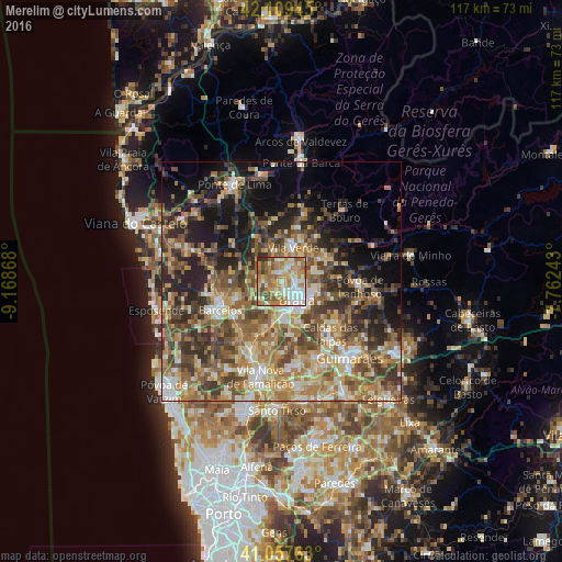
Analysis of Merelim night lights 2016
Square area 10x10 km:
100  13.31%
90-99 20.45%
80-89 9.25%
70-79 18.83%
60-69 19.81%
50-59 10.88%
40-49 4.87%
30-39 2.27%
20-29 0.32%
10-19 0%
0-9 0%
13.31%90-99
20.45%80-89
9.25%70-79
18.83%60-69
19.81%50-59
10.88%40-49
4.87%30-39
2.27%20-29
0.32%10-19
0%0-9
0%Square area 50x50 km:
100 3.56%
90-99 7.92%
80-89 6.69%
70-79 7.14%
60-69 10.06%
50-59 9.34%
40-49 8.92%
30-39 7.4%
20-29 10.14%
10-19 11.11%
0-9 17.71%
3.56%90-99
7.92%80-89
6.69%70-79
7.14%60-69
10.06%50-59
9.34%40-49
8.92%30-39
7.4%20-29
10.14%10-19
11.11%0-9
17.71%Clear (daylight) street map image can be seen on geolist.org.
Map coordinates:
42° 6' 34" North, 9° 10' 7.2" West
41° 35' 8.4" North, 8° 27' 56" West
41° 3' 27.5" North, 7° 45' 44.7" West
Some cities around Merelim sort by population:
• Braga
5.5 km =3.4 mi,  136°
136°
• Real
3.6 km =2.2 mi,  148°
148°
• Semelhe
3.5 km =2.2 mi,  176°
176°
• Gondizalves
5 km =3.1 mi,  170°
170°
• Arcos
8 km =5 mi, 152°
• Aveleda
7.2 km =4.5 mi, 180°
• Caldelas
11.8 km =7.3 mi,  36°
36°
• Galegos
9.2 km =5.7 mi,  253°
253°
2737723 (p: 5,363)
Sources (retrieved 2019-11-25):
» Earth at Night: Flat Maps 2012, 2016