Real night lights from space
Night Light of Real (Braga) from space (Portugal) Src. Average luminocity for 10x10km area is 82.9082% and for 50x50km: 47.4312%.
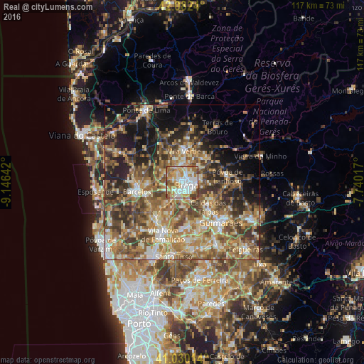
Analysis of Real night lights 2016
Square area 10x10 km:
100  24.83%
90-99 23.47%
80-89 7.82%
70-79 19.56%
60-69 14.29%
50-59 6.29%
40-49 3.74%
30-39 0%
20-29 0%
10-19 0%
0-9 0%
24.83%90-99
23.47%80-89
7.82%70-79
19.56%60-69
14.29%50-59
6.29%40-49
3.74%30-39
0%20-29
0%10-19
0%0-9
0%Square area 50x50 km:
100 3.83%
90-99 8.71%
80-89 7.01%
70-79 7.62%
60-69 11.09%
50-59 10.33%
40-49 9.26%
30-39 7.21%
20-29 9.64%
10-19 10.28%
0-9 15.04%
3.83%90-99
8.71%80-89
7.01%70-79
7.62%60-69
11.09%50-59
10.33%40-49
9.26%30-39
7.21%20-29
9.64%10-19
10.28%0-9
15.04%Clear (daylight) street map image can be seen on geolist.org.
Map coordinates:
42° 4' 56.6" North, 9° 8' 47.1" West
41° 33' 30.3" North, 8° 26' 35.9" West
41° 1' 48.5" North, 7° 44' 24.6" West
Some cities around Real sort by population:
• Braga
2.1 km =1.3 mi,  114°
114°
• Semelhe
1.7 km =1.1 mi,  254°
254°
• Gondizalves
2.1 km =1.3 mi,  208°
208°
• Arcos
4.5 km =2.8 mi,  155°
155°
• Aveleda
4.6 km =2.9 mi, 205°
• Oliveira
9.2 km =5.7 mi,  193°
193°
• Galegos
10.7 km =6.6 mi,  272°
272°
• Merelim
3.6 km =2.2 mi,  328°
328°
2735418 (p: 11,700)
Sources (retrieved 2019-11-25):
» Earth at Night: Flat Maps 2012, 2016