Gondizalves night lights from space
Night Light of Gondizalves (Braga) from space (Portugal) Src. Average luminocity for 10x10km area is 82.3963% and for 50x50km: 49.8438%.
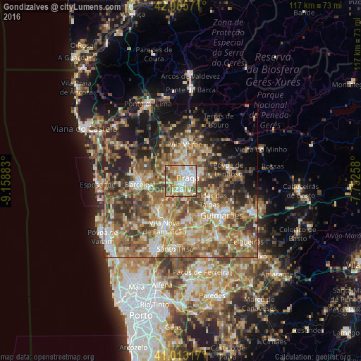
Analysis of Gondizalves night lights 2016
Square area 10x10 km:
100  23.81%
90-99 23.98%
80-89 9.35%
70-79 17.86%
60-69 13.27%
50-59 6.8%
40-49 4.93%
30-39 0%
20-29 0%
10-19 0%
0-9 0%
23.81%90-99
23.98%80-89
9.35%70-79
17.86%60-69
13.27%50-59
6.8%40-49
4.93%30-39
0%20-29
0%10-19
0%0-9
0%Square area 50x50 km:
100 4.15%
90-99 9.05%
80-89 7.25%
70-79 7.96%
60-69 12.1%
50-59 11.36%
40-49 9.62%
30-39 7.5%
20-29 9.52%
10-19 10.08%
0-9 11.42%
4.15%90-99
9.05%80-89
7.25%70-79
7.96%60-69
12.1%50-59
11.36%40-49
9.62%30-39
7.5%20-29
9.52%10-19
10.08%0-9
11.42%Clear (daylight) street map image can be seen on geolist.org.
Map coordinates:
42° 3' 56.6" North, 9° 9' 31.8" West
41° 32' 29.7" North, 8° 27' 20.5" West
41° 0' 47.4" North, 7° 45' 9.3" West
Some cities around Gondizalves sort by population:
• Braga
3.1 km =1.9 mi,  71°
71°
• Real
2.1 km =1.3 mi,  28°
28°
• Semelhe
1.5 km =0.9 mi,  337°
337°
• Arcos
3.6 km =2.2 mi,  127°
127°
• Aveleda
2.5 km =1.6 mi,  202°
202°
• Oliveira
7.1 km =4.4 mi,  189°
189°
• Galegos
10 km =6.2 mi,  283°
283°
• Merelim
5 km =3.1 mi,  350°
350°
2738928 (p: 9,148)
Sources (retrieved 2019-11-25):
» Earth at Night: Flat Maps 2012, 2016