Galegos night lights from space
Night Light of Galegos (Braga) from space (Portugal) Src. Average luminocity for 10x10km area is 64.8997% and for 50x50km: 46.998%.
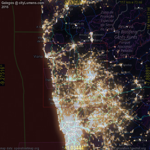
Analysis of Galegos night lights 2016
Square area 10x10 km:
100  4.93%
4.93%
90-99 10.88%
80-89 11.39%
70-79 11.05%
60-69 12.76%
50-59 22.62%
40-49 17.86%
30-39 7.65%
20-29 0.85%
10-19 0%
0-9 0%
4.93%90-99
10.88%80-89
11.39%70-79
11.05%60-69
12.76%50-59
22.62%40-49
17.86%30-39
7.65%20-29
0.85%10-19
0%0-9
0%Square area 50x50 km:
100 4.38%
90-99 8.94%
80-89 6.89%
70-79 7.35%
60-69 10.45%
50-59 9.3%
40-49 8.65%
30-39 6.63%
20-29 10.39%
10-19 12.91%
0-9 14.11%
4.38%90-99
8.94%80-89
6.89%70-79
7.35%60-69
10.45%50-59
9.3%40-49
8.65%30-39
6.63%20-29
10.39%10-19
12.91%0-9
14.11%Clear (daylight) street map image can be seen on geolist.org.
Map coordinates:
42° 5' 11.9" North, 9° 16' 30.6" West
41° 33' 45.6" North, 8° 34' 19.3" West
41° 2' 4" North, 7° 52' 8.1" West
Some cities around Galegos sort by population:
• Braga
12.7 km =7.9 mi,  96°
96°
• Barcelos
5.2 km =3.2 mi,  228°
228°
• Real
10.7 km =6.6 mi,  92°
92°
• Semelhe
9.1 km =5.7 mi, 95°
• Gondizalves
10 km =6.2 mi, 103°
• Aveleda
9.9 km =6.2 mi,  117°
117°
• Oliveira
12.7 km =7.9 mi,  137°
137°
• Merelim
9.2 km =5.7 mi,  73°
73°
2739118 (p: 5,404)
Sources (retrieved 2019-11-25):
» Earth at Night: Flat Maps 2012, 2016