Arcos night lights from space
Night Light of Arcos (Braga) from space (Portugal) Src. Average luminocity for 10x10km area is 74.852% and for 50x50km: 50.2535%.
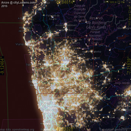
Analysis of Arcos night lights 2016
Square area 10x10 km:
100  21.43%
90-99 18.54%
80-89 7.14%
70-79 13.27%
60-69 10.2%
50-59 8.5%
40-49 11.73%
30-39 9.18%
20-29 0%
10-19 0%
0-9 0%
21.43%90-99
18.54%80-89
7.14%70-79
13.27%60-69
10.2%50-59
8.5%40-49
11.73%30-39
9.18%20-29
0%10-19
0%0-9
0%Square area 50x50 km:
100 3.76%
90-99 8.96%
80-89 7.22%
70-79 8.37%
60-69 12.64%
50-59 11.74%
40-49 10.02%
30-39 7.61%
20-29 9.44%
10-19 9.28%
0-9 10.97%
3.76%90-99
8.96%80-89
7.22%70-79
8.37%60-69
12.64%50-59
11.74%40-49
10.02%30-39
7.61%20-29
9.44%10-19
9.28%0-9
10.97%Clear (daylight) street map image can be seen on geolist.org.
Map coordinates:
42° 2' 46.1" North, 9° 7' 28.7" West
41° 31' 18.7" North, 8° 25' 17.4" West
40° 59' 35.8" North, 7° 43' 6.2" West
Some cities around Arcos sort by population:
• Braga
3.2 km =2 mi,  2°
2°
• Semelhe
5 km =3.1 mi,  316°
316°
• Real
4.5 km =2.8 mi,  335°
335°
• Gondizalves
3.6 km =2.2 mi,  307°
307°
• Aveleda
3.8 km =2.4 mi,  268°
268°
• Oliveira
6.3 km =3.9 mi,  219°
219°
• Caldas das Taipas
7.4 km =4.6 mi,  124°
124°
• Merelim
8 km =5 mi,  332°
332°
2742808 (p: 6,805)
Sources (retrieved 2019-11-25):
» Earth at Night: Flat Maps 2012, 2016