Caranguejeira night lights from space
Night Light of Caranguejeira (Leiria) from space (Portugal) Src. Average luminocity for 10x10km area is 35.5102% and for 50x50km: 24.0576%.
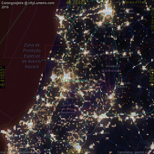
Analysis of Caranguejeira night lights 2016
Square area 10x10 km:
 0.51%
0.51%90-99
1.19%80-89
2.89%70-79
4.93%60-69
7.48%50-59
14.12%40-49
7.14%30-39
13.78%20-29
12.59%10-19
26.19%0-9
9.18%Square area 50x50 km:
1.46%90-99
2.48%80-89
1.75%70-79
2.4%60-69
3.66%50-59
5.49%40-49
4.76%30-39
5.71%20-29
10.42%10-19
25.4%0-9
36.46%Clear (daylight) street map image can be seen on geolist.org.
Map coordinates:
40° 17' 4.9" North, 9° 24' 37.9" West
39° 44' 46.3" North, 8° 42' 26.6" West
39° 12' 12.4" North, 8° 0' 15.4" West
Some cities around Caranguejeira sort by population:
• Leiria
8.5 km =5.3 mi,  268°
268°
• Marinha Grande
19.2 km =11.9 mi, 270°
• Ourém
15.3 km =9.5 mi,  139°
139°
• Fátima
14.7 km =9.1 mi,  161°
161°
• Maceira
17.2 km =10.7 mi,  248°
248°
• Batalha
13.9 km =8.6 mi,  226°
226°
• Porto de Mós
18.6 km =11.6 mi,  210°
210°
• Monte Real
17.8 km =11.1 mi,  311°
311°
2270211 (p: 5,248)
Sources (retrieved 2019-11-25):
» Earth at Night: Flat Maps 2012, 2016