Ourém night lights from space
Night Light of Ourém (Santarém) from space (Portugal) Src. Average luminocity for 10x10km area is 30.2695% and for 50x50km: 24.5329%.
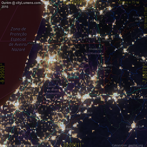
Analysis of Ourém night lights 2016
Square area 10x10 km:
 1.14%
1.14%90-99
1.62%80-89
2.92%70-79
4.38%60-69
4.87%50-59
4.06%40-49
8.28%30-39
7.79%20-29
16.4%10-19
39.29%0-9
9.25%Square area 50x50 km:
1.45%90-99
2.78%80-89
2.04%70-79
2.53%60-69
4.05%50-59
5.17%40-49
4.6%30-39
5.32%20-29
10.67%10-19
24.7%0-9
36.69%Clear (daylight) street map image can be seen on geolist.org.
Map coordinates:
40° 10' 51.6" North, 9° 17' 42.1" West
39° 38' 30" North, 8° 35' 30.8" West
39° 5' 53.2" North, 7° 53' 19.6" West
Some cities around Ourém sort by population:
• Leiria
21.6 km =13.4 mi,  301°
301°
• Entroncamento
22.2 km =13.8 mi,  151°
151°
• Tomar
16.3 km =10.1 mi,  105°
105°
• Torres Novas
18.9 km =11.7 mi,  167°
167°
• Fátima
5.7 km =3.5 mi,  245°
245°
• Batalha
20 km =12.4 mi,  275°
275°
• Porto de Mós
19.9 km =12.4 mi,  257°
257°
• Caranguejeira
15.3 km =9.5 mi,  319°
319°
2265388 (p: 12,729)
Sources (retrieved 2019-11-25):
» Earth at Night: Flat Maps 2012, 2016