Monte Real night lights from space
Night Light of Monte Real (Leiria) from space (Portugal) Src. Average luminocity for 10x10km area is 27.8741% and for 50x50km: 19.3675%.
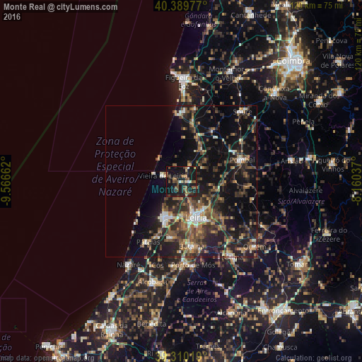
Analysis of Monte Real night lights 2016
Square area 10x10 km:
 0.85%
0.85%90-99
2.21%80-89
2.21%70-79
1.02%60-69
6.29%50-59
7.31%40-49
7.31%30-39
3.4%20-29
7.99%10-19
52.55%0-9
8.84%Square area 50x50 km:
1.29%90-99
2.24%80-89
1.5%70-79
2.03%60-69
3.16%50-59
4.23%40-49
3.89%30-39
4.29%20-29
7.67%10-19
18.62%0-9
51.09%Clear (daylight) street map image can be seen on geolist.org.
Map coordinates:
40° 23' 23.2" North, 9° 33' 59.8" West
39° 51' 7.6" North, 8° 51' 48.6" West
39° 18' 36.7" North, 8° 9' 37.3" West
Some cities around Monte Real sort by population:
• Leiria
13 km =8.1 mi,  158°
158°
• Marinha Grande
13 km =8.1 mi,  206°
206°
• Pombal
21.3 km =13.2 mi,  70°
70°
• Maceira
18.4 km =11.4 mi,  188°
188°
• Batalha
21.6 km =13.4 mi,  171°
171°
• Vieira de Leiria
6.2 km =3.9 mi,  288°
288°
• Caranguejeira
17.8 km =11.1 mi,  131°
131°
• Louriçal
20 km =12.4 mi,  32°
32°
2265844 (p: 5,756)
Sources (retrieved 2019-11-25):
» Earth at Night: Flat Maps 2012, 2016