Almodôvar night lights from space
Night Light of Almodôvar (Beja) from space (Portugal) Src. Average luminocity for 10x10km area is 3.2062% and for 50x50km: 1.1245%.
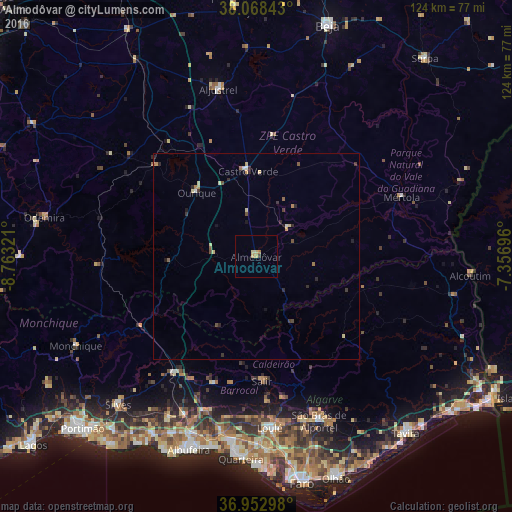
Analysis of Almodôvar night lights 2016
Square area 10x10 km:
 0%
0%90-99
0%80-89
1.3%70-79
1.3%60-69
0.65%50-59
0%40-49
0%30-39
0.65%20-29
0%10-19
0%0-9
96.1%Square area 50x50 km:
0.07%90-99
0.04%80-89
0.31%70-79
0.19%60-69
0.12%50-59
0.14%40-49
0.16%30-39
0.27%20-29
0.31%10-19
0.22%0-9
98.18%Clear (daylight) street map image can be seen on geolist.org.
Map coordinates:
38° 4' 6.3" North, 8° 45' 47.6" West
37° 30' 46" North, 8° 3' 36.3" West
36° 57' 10.7" North, 7° 21' 25.1" West
Some cities around Almodôvar sort by population:
• Loulé
41.9 km =26 mi,  175°
175°
• São Brás de Alportel
42.8 km =26.6 mi,  159°
159°
• Almancil
47.4 km =29.5 mi, 176°
• São Bartolomeu de Messines
34.8 km =21.6 mi,  215°
215°
• Mértola
38 km =23.6 mi,  67°
67°
• Monchique
48.8 km =30.3 mi,  243°
243°
• Aljustrel
41.6 km =25.8 mi,  347°
347°
• Ferreiras
45.4 km =28.2 mi,  200°
200°
2271912 (p: 7,449)
Sources (retrieved 2019-11-25):
» Earth at Night: Flat Maps 2012, 2016