São Bartolomeu de Messines night lights from space
Night Light of São Bartolomeu de Messines (Faro) from space (Portugal) Src. Average luminocity for 10x10km area is 11.7262% and for 50x50km: 16.5049%.
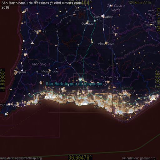
Analysis of São Bartolomeu de Messines night lights 2016
Square area 10x10 km:
 0.68%
0.68%90-99
0.85%80-89
1.19%70-79
1.36%60-69
1.36%50-59
2.21%40-49
2.55%30-39
2.04%20-29
2.04%10-19
4.76%0-9
80.95%Square area 50x50 km:
1.81%90-99
1.99%80-89
2.66%70-79
2.01%60-69
3.56%50-59
2.4%40-49
2.16%30-39
2.98%20-29
6.11%10-19
8.86%0-9
65.45%Clear (daylight) street map image can be seen on geolist.org.
Map coordinates:
37° 48' 50.5" North, 8° 59' 23.5" West
37° 15' 23.3" North, 8° 17' 12.2" West
36° 41' 41.1" North, 7° 35' 1" West
Some cities around São Bartolomeu de Messines sort by population:
• Portimão
25.8 km =16 mi,  239°
239°
• Quarteira
26.5 km =16.5 mi,  141°
141°
• Albufeira
19 km =11.8 mi,  170°
170°
• Silves
15.4 km =9.6 mi, 240°
• Estômbar
21.4 km =13.3 mi, 235°
• Lagoa
20 km =12.4 mi,  227°
227°
• Monchique
24.7 km =15.3 mi,  285°
285°
• Ferreiras
14.8 km =9.2 mi,  162°
162°
2263393 (p: 8,381)
Sources (retrieved 2019-11-25):
» Earth at Night: Flat Maps 2012, 2016