São Brás de Alportel night lights from space
Night Light of São Brás de Alportel (Faro) from space (Portugal) Src. Average luminocity for 10x10km area is 30.9405% and for 50x50km: 15.5144%.
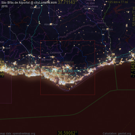
Analysis of São Brás de Alportel night lights 2016
Square area 10x10 km:
 1.87%
1.87%90-99
0.85%80-89
4.25%70-79
3.74%60-69
10.37%50-59
4.42%40-49
2.38%30-39
8.33%20-29
15.31%10-19
28.06%0-9
20.41%Square area 50x50 km:
1.32%90-99
1.24%80-89
2.67%70-79
1.98%60-69
3.86%50-59
2.08%40-49
2.45%30-39
3.55%20-29
4.85%10-19
10.29%0-9
65.71%Clear (daylight) street map image can be seen on geolist.org.
Map coordinates:
37° 42' 41.1" North, 8° 35' 26.3" West
37° 9' 11.2" North, 7° 53' 15" West
36° 35' 26.2" North, 7° 11' 3.8" West
Some cities around São Brás de Alportel sort by population:
• Faro
15.4 km =9.6 mi,  193°
193°
• Olhão
14.4 km =8.9 mi,  163°
163°
• Loulé
11.8 km =7.3 mi,  261°
261°
• Laranjeiro
11.8 km =7.3 mi,  143°
143°
• Quarteira
21.1 km =13.1 mi,  243°
243°
• Tavira
21.4 km =13.3 mi,  97°
97°
• Almancil
14.7 km =9.1 mi, 239°
• Moncarapacho
11.8 km =7.3 mi,  131°
131°
2263377 (p: 11,153)
Sources (retrieved 2019-11-25):
» Earth at Night: Flat Maps 2012, 2016