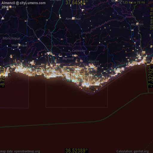
Almancil night lights from space
Night Light of Almancil (Faro) from space (Portugal) Src. Average luminocity for 10x10km area is 62.9983% and for 50x50km: 18.4098%.
Analysis of Almancil night lights 2016
Square area 10x10 km:
 3.06%
3.06%90-99
5.1%80-89
16.5%70-79
11.73%60-69
26.19%50-59
10.2%40-49
10.03%30-39
14.63%20-29
2.55%10-19
0%0-9
0%Square area 50x50 km:
1.68%90-99
1.72%80-89
3.07%70-79
2.19%60-69
4.71%50-59
2.68%40-49
2.95%30-39
3.9%20-29
6.16%10-19
10.22%0-9
60.72%Clear (daylight) street map image can be seen on geolist.org.
Map coordinates:
37° 38' 44.4" North, 8° 44' 1.9" West
37° 5' 12.7" North, 8° 1' 50.7" West
36° 31' 26" North, 7° 19' 39.4" West
Some cities around Almancil sort by population:
• Faro
11.9 km =7.4 mi,  129°
129°
• Olhão
18 km =11.2 mi,  111°
111°
• Loulé
5.7 km =3.5 mi,  9°
9°
• Laranjeiro
19.9 km =12.4 mi,  96°
96°
• Quarteira
6.5 km =4 mi,  252°
252°
• Albufeira
19.5 km =12.1 mi,  270°
270°
• São Brás de Alportel
14.7 km =9.1 mi,  59°
59°
• Ferreiras
18.9 km =11.7 mi,  284°
284°
2271947 (p: 9,898)
Sources (retrieved 2019-11-25):
» Earth at Night: Flat Maps 2012, 2016