Alcochete night lights from space
Night Light of Alcochete (District of Setúbal) from space (Portugal) Src. Average luminocity for 10x10km area is 40.9677% and for 50x50km: 42.0476%.
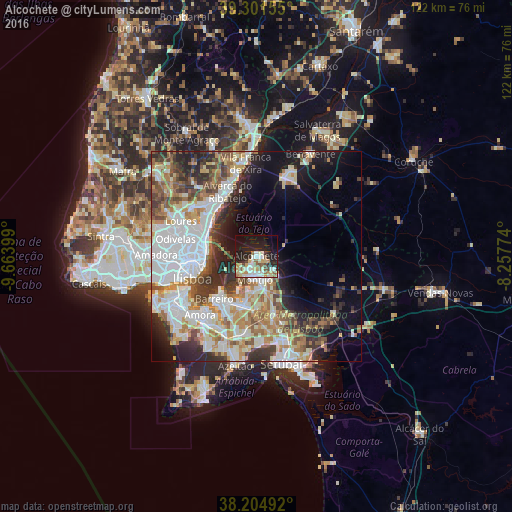
Analysis of Alcochete night lights 2016
Square area 10x10 km:
 6.63%
6.63%90-99
9.86%80-89
6.46%70-79
5.78%60-69
2.89%50-59
5.61%40-49
3.57%30-39
2.04%20-29
13.1%10-19
24.66%0-9
19.39%Square area 50x50 km:
12.17%90-99
9.42%80-89
3.85%70-79
4.71%60-69
5.61%50-59
5.06%40-49
4.07%30-39
5.5%20-29
7.49%10-19
9.44%0-9
32.68%Clear (daylight) street map image can be seen on geolist.org.
Map coordinates:
39° 18' 5.6" North, 9° 39' 50.4" West
38° 45' 19.2" North, 8° 57' 39.1" West
38° 12' 17.7" North, 8° 15' 27.9" West
Some cities around Alcochete sort by population:
• Olivais
12.8 km =8 mi,  277°
277°
• Montijo
5.5 km =3.4 mi,  191°
191°
• Moscavide e Portela
12.5 km =7.8 mi, 282°
• Lavradio
12.5 km =7.8 mi,  219°
219°
• Moita
11.9 km =7.4 mi, 192°
• Alhos Vedros
12.4 km =7.7 mi,  206°
206°
• Beato António
12.6 km =7.8 mi,  258°
258°
• Bobadela
13.3 km =8.3 mi,  295°
295°
2272144 (p: 9,705)
Sources (retrieved 2019-11-25):
» Earth at Night: Flat Maps 2012, 2016