Moita night lights from space
Night Light of Moita (District of Setúbal) from space (Portugal) Src. Average luminocity for 10x10km area is 76.5584% and for 50x50km: 40.5798%.
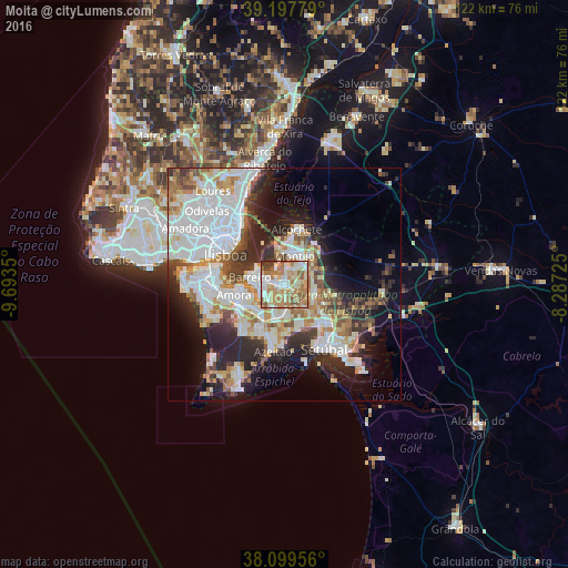
Analysis of Moita night lights 2016
Square area 10x10 km:
 13.8%
13.8%90-99
20.78%80-89
12.34%70-79
12.18%60-69
23.7%50-59
9.74%40-49
3.08%30-39
4.38%20-29
0%10-19
0%0-9
0%Square area 50x50 km:
12.43%90-99
9.59%80-89
3.56%70-79
4.58%60-69
4.81%50-59
4.06%40-49
3.01%30-39
4.74%20-29
8.61%10-19
10.07%0-9
34.54%Clear (daylight) street map image can be seen on geolist.org.
Map coordinates:
39° 11' 52" North, 9° 41' 36.6" West
38° 39' 2.8" North, 8° 59' 25.4" West
38° 5' 58.4" North, 8° 17' 14.1" West
Some cities around Moita sort by population:
• Barreiro
7.3 km =4.5 mi,  280°
280°
• Arrentela
10.1 km =6.3 mi,  253°
253°
• Montijo
6.4 km =4 mi,  12°
12°
• Pinhal Novo
7 km =4.3 mi,  108°
108°
• Lavradio
5.7 km =3.5 mi,  289°
289°
• Alhos Vedros
2.9 km =1.8 mi, 278°
• Aldeia de Paio Pires
8.9 km =5.5 mi,  244°
244°
• Santo António da Charneca
4.5 km =2.8 mi,  231°
231°
2266319 (p: 17,795)
Sources (retrieved 2019-11-25):
» Earth at Night: Flat Maps 2012, 2016